Creating An Automated Raspberry Pi and RTL-SDR Based NOAA Weather Satellite Station
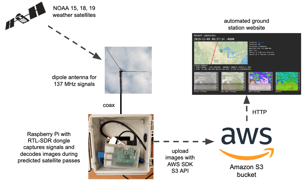
The nootropicdesign blog has recently uploaded a comprehensive tutorial showing how to create an automated NOAA Weather Satellite ground station using an RTL-SDR V3 and an Raspberry Pi 3. The project also makes use of an Amazon S3 bucket, which is a cheap web storage platform that allows you to store and access the downloaded images.
The tutorial starts by showing you how to set up your Amazon AWS credentials and bucket on the Raspberry Pi, and how to host a simple webpage that can be accessed publicly. The second stage shows how to set up the RTL-SDR drivers and wxtoimg which is used to decode the images. Finally, the third stage shows how to create the automation scripts that automatically schedule a decode, and upload images to the AWS bucket.


he visto por aqui alguien que decia haber trabajado este sistema “hace 15 años” y es cierto, el trabajar con sistemas via satelite y todos los sistemas digitales, por lo menos en Argentina los usamos desde principios de 1980 ademas de transmisiones en HF por satelites, de orbita eliptica como circular y con la estacion espacial tanto en fonia como digital en paket, o sea hace mas de 40 años! por esa fecha,nuestro grupo fue el pionero en Argentina, junto al resto del mundo. un saludo a todos los experimentadores de electronica, comunicaciones, robotica e impresion 3D, etc.. LU5END
If you count all the hardware (including Amazon AWS hardware) then it’s gonna be a bit higher than $60.
If the goal is to achieve the result at minimal possible cost then it could be done at near zero cost by just using results produced and uploaded to the Internet by someone else.
Anyway, the project is pretty cool, even though use of AWS is questionable.
Seeing as you can get NOAA sat images online for free in near real time its all a bit pointless really.
You could say the same to the millions of world travelers…why travel when you can see pix on line of the same places…
Was doing that 25 years ago !
But with only $60 worth of hardware?
No about 100 worth of old scanner and some software for auto uploading to a server, why do you even need 60 of hardware today, if you already have a p.c you only need a cheap dongle for 10-15, software can do the rest.
twat… sure why bother doing anything, stay in bed.