Over on YouTube Gabe from the saveitforparts channel has uploaded a new video discussing the decommissioning of NOAA-15 and NOAA-19. We also previously posted about this topic a few days ago, if you are interested.
NOAA-15 was scheduled to shut down on August 12, 2025, but due to anomalies with NOAA-19, the decommissioning date of NOAA-15 has been extended by a few days until the week of August 18th. NOAA-19 has recently been experiencing transmitter failures, and it may be impossible to receive signals from it at the moment, despite its expected decommissioning date of August 19, 2025.
In the video, Gabe also rushes to try and receive signals from all transmitters on NOAA-15 one last time, setting up VHF, L-Band, and S-Band receivers. He experiences some issues with weak signals, interference, and recording failures, but ultimately succeeds in capturing all three signals during one of the final passes of NOAA-15.
US Government Shutting Down More Weather Satellites
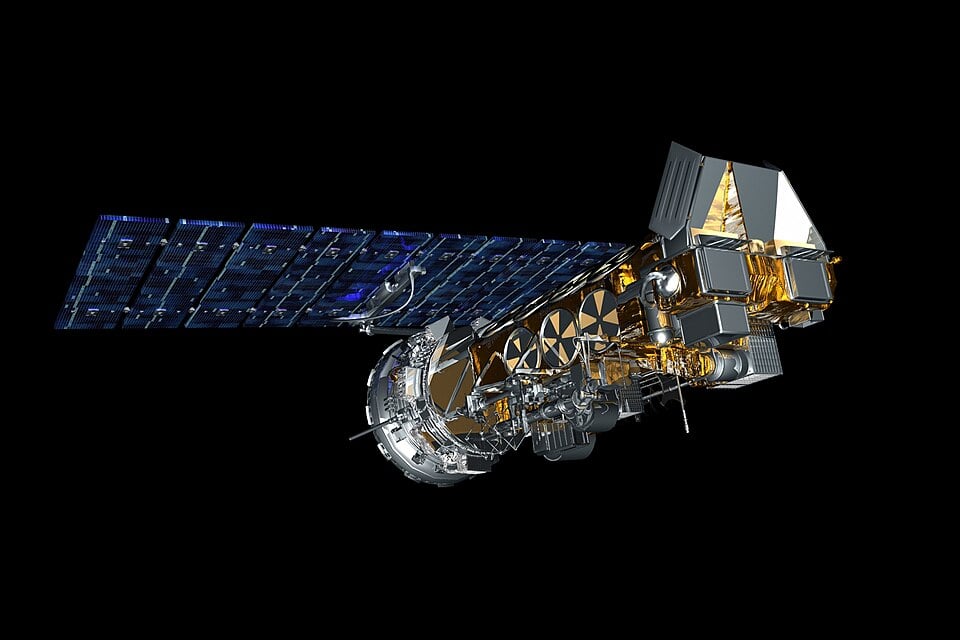
The National Oceanic and Atmospheric Administration (NOAA) have recently announced that they are planning to decommission NOAA 15 and NOAA 19 on August 12, 2025 and August 19, 2025 respectively.
Update #7: NOAA has completed End of Life (EOL) testing activities for NOAA-15 and NOAA-19 and will commence the decommission process shortly. These two remaining satellites in the NOAA Polar Operational Environmental Satellites (POES) Constellation are far beyond their primary mission design life. All have incurred subsystem and instrument degradation or failures and have entered a "twilight phase" where failure modes are increasingly likely. As a reminder, NOAA-18 was decommissioned on June 6, 2025 at 1740 UTC due to an unrecoverable failure to the S-Band transmitter. The remaining satellites in the legacy POES constellation will be decommissioned as follows: NOAA-15 on August 12, 2025 and NOAA-19 on August 19, 2025.
NOAA-15, NOAA-18, and NOAA-19 have long been core satellites for RTL-SDR users. For many of us, one of these would have been the first satellite from which we received weather data via the 137 MHz APT signal.
These NOAA satellites were marked end-of-life (EOL) back on June 16, 2025. However, EOL status still meant that transmissions would continue as normal. The EOL status simply marked that the satellites should no longer be used for mission-critical services, and that no attempts at repair or recovery would be made if needed.
On June 06, 2025, just before the EOL status officially went into effect, NOAA-18 was decommissioned and shut down due to a prior transmitter failure that left ground control in danger of being unable to control the satellite in the future.
While nothing critical appears to have happened to the remaining NOAA-15 and NOAA-19 satellites as of yet, these are ageing satellites with various ongoing issues. NOAA-15 was launched in 1998, and NOAA-19 in 2009. They have long exceeded their design life.
As with NOAA-18's decommissioning, it does not appear that NOAA will deorbit the satellites. Instead, they will be left in orbit and put into a safe electrical state, with the transmitters shut down.
A few days ago, we posted news that NOAA-18 was to begin decommissioning steps effective immediately due to a recent transmitter failure. Multiple reports have now confirmed that NOAA-18 has indeed shut down as of 1740 UTC 06/06/2025.
In April, we posted news that the NOAA satellites would be classed as 'end-of-life' on June 16, 2025. According to the statements, the satellites were expected to remain in orbit and continue transmitting data that radio hobbyists could use, but no attempts would be made to rectify failures.
NOAA-18 may have been chosen to be decommissioned earlier than NOAA-15 and NOAA-19 as the S-band downlink transmitter failed last month, resulting in severe image degradation. The satellite has also been running on backup gyros since 2017, and has suffered various transmitter and sensor failures over the years.
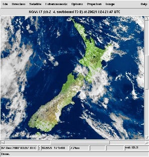
Dr. Sasha Engelmann and Sophie Dyer, the team behind the Open-Weather project have recently announced the launch of their new version of open-weather apt, a web-based NOAA APT image decoder. The web-based program accepts a WAV file containing a NOAA satellite APT recording, demodulates and decodes it, and displays the resulting weather satellite image.
Open-weather apt is the only public, maintained, browser-based decoder for Automatic Picture Transmissions (APT) from satellites NOAA-19, NOAA-18 and NOAA-15. It was developed to improve access to satellite signal decoding for all practitioners.
We are excited to share a new and improved version available here! The new version includes the following updates and additional features:
Improved accuracy in decoding and finding sync positions (locates more sync positions than other comparable decoders)
Upload a WAV file of any sample rate (no more re-sampling with Audacity!)
Option to see the ‘raw’ image without syncing, and to ‘Find the Syncs’
Option to Rotate 180 degrees, often useful for viewing images from nighttime passes
Go deeper in your analysis: explore Signal Value and Image Value Histograms
Upload directly from open-weather apt to the Public Archive
Open-weather apt is co-developed by open-weather with Rectangle (Lizzie Malcolm and Dan Powers), Bill Liles (NQ6Z) and Grayson Earle. We have had a lot of fun testing and experimenting. Please let us know if you have feedback!
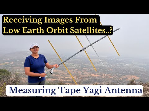
Over on her YouTube channel IndiaRocketGirl (@VU3BIZ) has posted a video showing how she was able to receive weather satellite images from the polar orbiting NOAA-19 weather satellite at 137 MHz.
She uses a home made four element Yagi antenna with elements made from a tape measure. This allows the elements to be easily folded down for transportation. A phone running the Heaven's above app is used to help track the satellite in the sky as it passes over, and then SatDump and an RTL-SDR Blog V3 running on a laptop is used to decode the signal into an image.
IndiaRocketGirl notes that in her next video she will show how to make the Yagi antenna that she was using. In a previous post IndiaRocketGirl also showed how she was able to receive geostationary FengYun-2H S-VISSR signals.
How to Receive Real Time Images from Low Earth Orbit Satellites | India Rocket Girl | NOAA-19
WXCorrector is a dedicated solution designed specifically for Linux users who face challenges with the handling of Kepler elements in Wxtoimg. This tool addresses a critical issue where incorrect or outdated Keplerian elements can cause disruptions in tracking software, leading to inaccurate predictions and potential data loss.
It work on Linux, it needs sudo rights and Python3 installed.
WXtoIMG is a commonly used piece of software for decoding images from NOAA APT weather satellites. However, WXtoIMG is now considered abandonware as the original website has gone, and the main author has not updated the program in many years. The latest versions from 2017 can be downloaded from Archive.org. An alternative download site is https://www.wraase.de/wxtoimg, where they also provide a way to update Keplers for Windows machines.
Due to it's abandonment, certain features like Kepler updates from the internet appear to have broken over time with changes to the way Kepler files are served. Up to date Kepler files are required for the software to know exactly where satellites are in the sky for tracking and scheduling.
A modern alternative to WXtoIMG is SatDump, which now supports NOAA APT satellites.
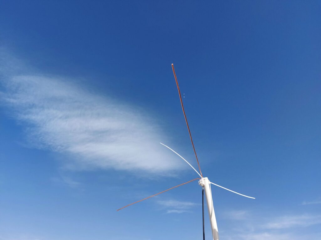
On his Medium.com blog, Mohsen Tahmasebi has posted an article about his journey into listening to satellites which started with his acquisition of an RTL-SDR Blog V3 dongle. The article begins by explaining his motivations for receiving satellites and how difficult hobbies like this are to get into in his home country of Iran. Despite the challenges he tasted success when he was able to receive NOAA APT signals on his second attempt using the included portable dipole antenna in a V-dipole configuration. Shortly after Mohsen was also able to receive Meteor-M2 LRPT.
Mohsen then built a more permanent V-dipole out of copper rods and optimized his antenna using NEC simulation software, finding that adding a reflector significantly improved reception. He then moved on to building a slightly more complex Turnstile antenna, which yielded even better results and allowed him to explore CubeSats at 435 MHz and contribute to SatNOGS. Finally, Mohsen ordered a Bullseye LNB and using a homemade bias tee, he received the QO-100 amateur radio transponder.
Overall, Mohsen's journey demonstrates that there is a lot of fun and learning available from internationally available satellites even in a country where equipment is hard to come by.
Mohsen's First Permanent V-Dipole for NOAA APT Reception