Triangulation of a VHF Signal with RTLSDR-Scanner
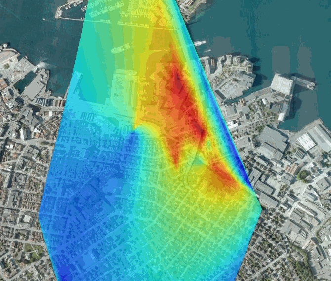
A few months back we posted about how the the RTLSDR-Scanner software had been updated to include signal triangulation capabilities. Now blogger Tobby has written a post about his attempt at triangulating the source of an encrypted police signal with RTLSDR-Scanner.
To do this he set up a laptop in his car with RTLSDR-Scanner installed and connected his RTL-SDR with stock antenna and a GPS receiver. After driving around for only 15 minutes he was able to get a triangulation heat map of reasonable accuracy.


The article has been removed. Find it here https://web.archive.org/web/20150419183434/https://theanatomize.blogspot.no/2014/07/locating-source-of-signal-with-rtl-sdr.html
Thanks for the link
Good evening,
Is it possible to create a system of many SDR receivers that can triangulate the location of emergency response vehicles as they patrol the city with affordable off the shelf parts?
Technically this is a signal strength heatmap, not really triangulation.. Cool tho 🙂
HELLO TOBBY , FOR YOUR INFORMATION, I HAVE MADE A CARD HOT POINTS OF MY REGION WITH THE SOFTWARE RTLSCANNER THE FRIEND AL. CARD NOW COVERS AN AREA OF 600KM2 WITH A SCAN ANY BAND A 55 MHZ 1000 MHZ. WHY I HAVE TO HAVE 4 CAMPAIGNS FIELD MEASUREMENTS WITH A TOTAL OF ABOUT 90 POINTS FOR FIXED MY RECORDS TOGETHER AND THEN THE 4 BACKUP FILES IN ONE … IT WORKS VERY WELL AND IT IS POSSIBLE FROM FILE BACKUP SCAN TO PUBLISH IN EXPORT MAP GPS MAPS OF ANY RATE OF LOCAL STATIONS WITH A SUITABLE CHOICE FOR MODULATION OF STATION FOR BANDWIDTH. I WANT SOME IMAGES AVAILABLE TO YOU : WRITE ME TO MY EMAIL ADDRESS PERSONAL [email protected]. THANKS PASCAL
Assuming you have the following:
Using Debian Linux
This Program installed
GPSD installed
RTL-SDR dongle
GPS dongle that is compatable with GPSD (use xgps or cgps to check to see if its working ok, troubleshoot as needed)
If all is working in the Scanner set your freq range
Then under “Mode” choose “Continuous”
Under “Dwell” choose a lower number I used 32ms
then click start and drive around
After you find a safe spot to pull over, hit STOP
Then File and Export to MAP
This will save a file that GoogleEarth can read.
Open it in GoogleEarth just by File and OPEN
it should automatically overlay the heat map on it assuming again that you have an internet connection that will load the terrain.
There were some decencies for the Scanner that you will probably have to resolve I think i was missing python-serial but rest of the decencies are: wxPython matplotlib numpy Pillow rtlsdr pyrtlsdr
Also too, gpsd is a pain. I hope you have a supported dongle or you’ll end up like me. I had a dg-100 from globalsat. Found out after much hair pulling you had to install globledog-dg100 and start mouse mode. Only then did gpsd find my GPS dongle. Since the scanner is looking at gpsd on port 2947 if all goes well there wont be any need to mess with settings on the Scanner.
After that everything worked.
Hope this helps.
Epsilon519