With the recent release of ADSBSpy, an ADS-B decoder for the Airspy software defined radio, many people have been wondering how much better the Airspy is compared to the low cost RTL-SDR dongle at ADS-B reception. Over on his blog, Anthony Stirk has performed a test comparing an E4000 RTL-SDR with the Airspy.
In his test Anthony uses an A3 ADS-B antenna from Jetvision.de, and a HABAMP which is an LNA plus 1090 MHZ SAW filter. To create a fair test he used an antenna splitter and measured the reception of both dongles at the same time. He ran one instance of ADSB# for the E4000 RTL-SDR, and one instance of ADSBSpy for the Airspy over 24 hours and recorded the results.
Airspy vs E4000 RTL-SDR
The results showed that the Airspy had approximately 50 km more range compared to the E4000 in some areas. More interestingly the stats showed that the Airspy received approximately 7 million more ADS-B messages compared to the RTL-SDR.
While there is no doubt the Airspy will perform better, one thing to note about this test is that it used an E4000 RTL-SDR which is widely considered to have inferior performance at the 1090 MHz ADS-B frequency when compared to the R820T/2 dongles.
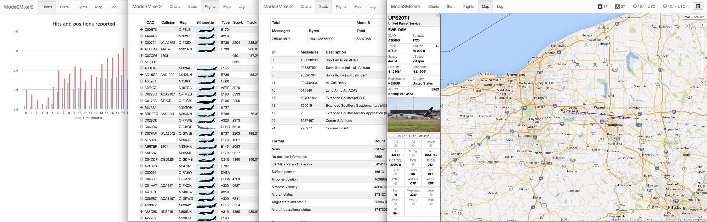
The author’s tutorial goes over setting up ModeSDeco2 to broadcast data over the network, setting up ModeSMixer2 to receive data, and also setting up the basestation.sqb file to add airline logos and silhouettes to the web based GUI of ModeSMixer2.
Over on the SonicGoose.com blog, the author has recently created a tutorial showing how to use Modesdeco which is a multi platform command line ADS-B decoding software application. ADS-B stands for Automatic Dependent Surveillance Broadcast and is a signal broadcast by aircraft that can be used to track them like a radar.
Modesdeco is a command line ADS-B decoder quite similar in purpose to other software like dump1090, RTL1090 and ADSB#, however it has more available features built into it. The blog author writes about Modesdeco:
Want to feed BaseStation and PlanePotter at the same time? No problem. Want to add another data stream for Virtual Radar Server? No problem. Want statistics about the types of data being received? No problem. Want to run it on a variety of platforms, including Windows, Mac OS X, Linux, or the RaspberryPi? No problem.
The author’s tutorial goes over setting up the software on Windows and turning on some features like it’s web statistics interface, interactive map and how to feed data to another virtual radar application like Basestation. In the future the author plans to write a second tutorial showing how to use another feature which allows a user to combine the ADS-B feeds from various computers running Modesdeco.
Screenshot of the Modesdeco statistics web interface.
In most of the world aircraft use the ADS-B standard for location tracking which transmits at a frequency of 1090 MHz. However, in the USA there is the option for aircraft to instead use the Universal Access Transceiver (UAT) protocol which transmits at 978 MHz.
UAT has some extra features for pilots compared to ADS-B. In addition to location information UAT provides a Traffic Information Service (TIS/B) which allows pilots to see what ground control sees on their traditional RADAR system. It also provides a Flight Information Service-Broadcast (FIS/B) which includes weather and other information. It seems that most small aircraft in the USA prefer to use the UAT system due to it’s lower cost and additional features.
Recently Roman, a programmer and reader of RTL-SDR.com wrote in to let us know about his ADSBox software which is a free opensource Linux based ADS-B decoder (page in Russian, use Google Translate) with several interesting features. ADSBox contains a decoder and a nice web interface which allows you to view flight information in a table or in Google maps, or even through a Google Earth interface. The software also automatically loads up a photo of an aircraft if you click on it in the map. Roman has actually been working on ADSBox since 2011 and seems to have recently added RTL-SDR support.
The software can be compiled on a PC with gcc, or on an embedded ARM device with arm-linux-gcc. We gave the software a quick test on an Ubuntu PC and found that it worked as expected. Install instructions are on the page linked above, but just in case here are our notes on compiling the software.
Download and extract the latest version from the bottom of the page into a folder called adsbox on your Linux system. (Latest version at the time of writing: adsbox-20150409.tar.gz. Note that the Google translated download link did not work for us, use the original untranslated link if you need to)
Download and extract the latest sqlite source files from http://www.sqlite.org/download.html (at the time of writing: sqlite-amalgamation-3080900.zip) into a folder called sqlite3 on the same level as the extracted adsbbox folder (not inside adsbbox folder)
Edit the Makefile and set “WITH_RTLSDR = yes”. If cross-compiling for an ARM device set CC = arm-linux-gcc, otherwise leave this setting alone.
Run “make”.
Now you can run ADSBox with ./adsbox –rtlsdr.
Go to 127.0.0.1:8080 in your browser to see and use the interface.
Over on the Raspberry Pi Reddit discussion board user spfoamer has posted about his Raspberry Pi + RTL-SDR based outdoor ADS-B receiver. ADS-B stands for Automatic Dependent Surveillance Broadcast and is a signal broadcast by aircraft that contains information about their locations. With a receiver like the RTL-SDR and correct software you can make an aircraft radar.
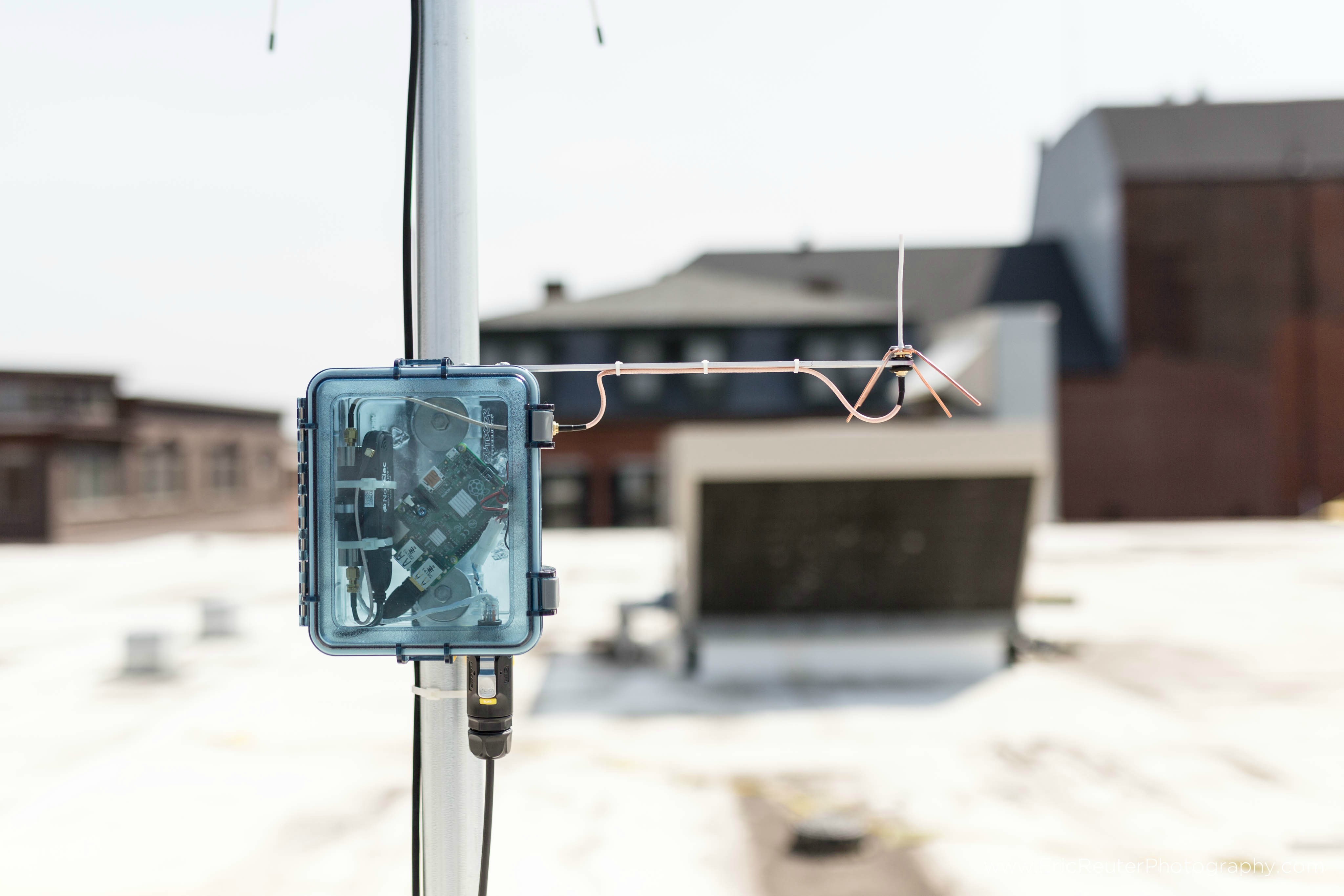
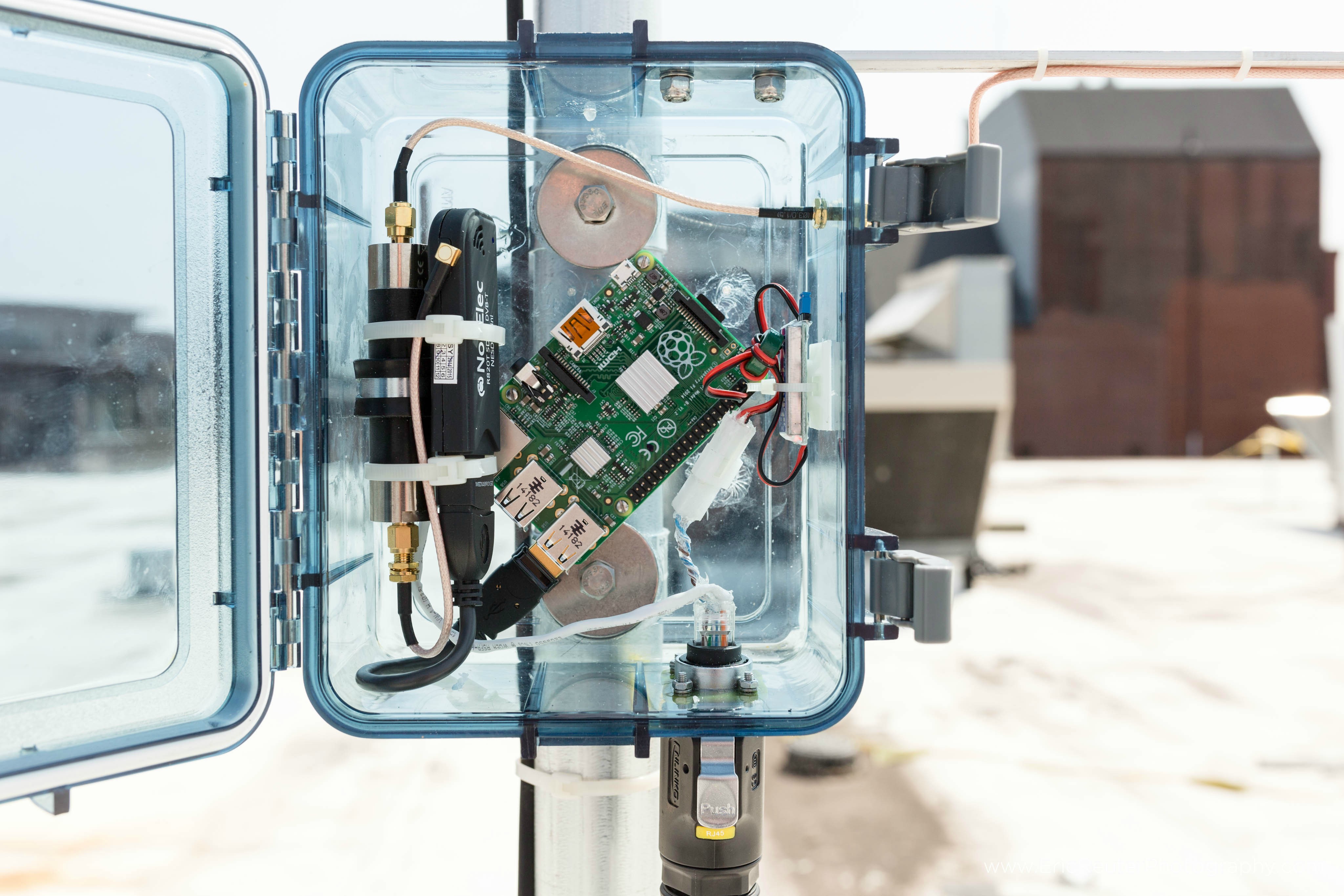
In his design the Raspberry Pi transmits location data back to a PC via an Ethernet cable. In addition the Raspberry Pi is also cleverly powered via power over Ethernet (POE) which uses unused wires in the Ethernet cable itself to carry the power. Since he uses a 12V power source, to obtain the needed 5V to power the Raspberry Pi spfoamer uses a UBEC (Universal Battery Elimination Circuit) which is an efficient device that converts voltages from up to 23V down to 5V. Additionally, he uses a 1/4 wave ground plane antenna and a 1090 MHz bandpass filter to eliminate out of band interference.
On the Pi itself he runs PiAware and contributes his data to the FlightAware network.
ADS-B with a Raspberry Pi, RTL-SDR, Bandpass Filter all powered via Ethernet cable.Close up of the inside of the box.
Recently we bought and tested one of Adam 9A4Qv’s ADS-B folded monopole antennas. This is a well thought out 50 ohm antenna designed for receiving ADS-B signals between 1030 and 1090 MHz. It has an omni directional radiation pattern (receives from all directions in the horizontal) and 3.67 dBi gain.
This antennas main defining feature is that it uses a DC grounded design which eliminates the static electricity problems other antennas can have. This allows this antenna to be connected to a receiver 24/7 without having to worry about ESD destroying the front end of your receiver or LNA. It is also small enough to be able to be used as a desktop antenna.
Folded Monopole ADS-B Antenna. Comes in two pieces which need to be soldered together.
The antenna is made of FR-4 laminate (PCB material) with a conductive layer covering the ground plane board and an upside down U-shaped trace in the vertical section. The antenna requires assembly and detailed assembly steps can be found on the antenna’s web page. Assembly of the antenna itself was straight forward just requiring two solder joints to be made to connect the vertical part to the ground plane. You will need to take care to ensure that the vertical antenna is completely vertical once soldered in.
The antenna also comes with no included coax cable and so a cable must be soldered on to the antenna first. The assembly instructions recommend using Teflon coax cable (such as RG316), however we didn’t have any on hand, so we just used regular RG174U and carefully soldered it on, making sure to not melt the inner insulation too much.
Fully constructed ADS-B antenna with RTL-SDR dongle for size comparison.
After fully constructing the antenna we ran a SWR test using an RTL-SDR and a noise source and found the antenna to have a SWR of approximately 1.46 at 1090 MHz resulting in about a 0.155 dB loss due to mismatches. A SWR value of 1.46 is very good for a receive only antenna like this. In one of Adams videos he used some higher quality coax and his tests showed the SWR of the antenna with a value of about 1.2102.
As for actual real world ADS-B performance we did not test it against any other ADS-B antennas, but it received aircraft from almost 350 km away from an indoor desktop location which we think is pretty good. In comparison the standard 11.5 cm stock antenna that comes with most dongles only had a range of about 250 km when placed in the same location. The maximum range of an ADS-B signal is around 500 – 600 km, which should be easily achievable with this antenna mounted outside on the roof.
Compared to other hobbyist ADS-B antenna offerings, Adam’s folded monopole antenna is one of the cheapest we could find, costing only 20 euros + 5 euros for shipping (~$26.5 USD total), although it does not come with a mount or weatherproofing. It is also one of the smallest, measuring just under 6 cm high and 14 cm in width and depth. Below we table Adam’s antenna with some alternatives for a comparison (prices converted from Euro to USD where applicable).
Note remember that as passive antenna gain is increased, the receive radiation pattern becomes flatter (which you may or may not want – you’ll receive better out towards the horizon but worse at higher elevations) and that an active antenna with an LNA is most useful when long runs of coax cable is used.
Flightaware.com is a web based online radar service for aircraft. The plane position data is obtained from contributors running ADS-B decoding hardware, such as a special ADS-B receiver box or simply an RTL-SDR dongle.
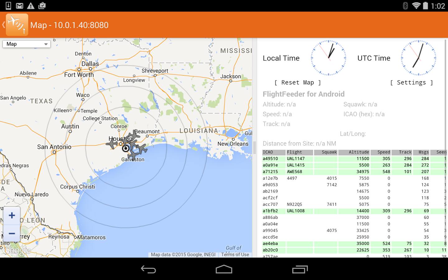
To increase the number of contributors, the team at FlightAware have released a new RTL-SDR compatible ADS-B decoder app for Android devices. The App is totally free and is also ad free. It can be downloaded from the Google Play store at https://play.google.com/store/apps/details?id=com.flightaware.android.flightfeeder. The intention of the app is to target users who may have an old Android device lying around, which can be put to good use in contributing data to FlightAware. More information about running the app can be found on their webpage.
When sharing data with FlightAware you are then eligible for a free enterprise account valued at $89.95 a month which allows you to access several advanced flight tracking features.
To use the app you’ll need an Android device, a USB OTG cable (ideally with external power port) and an RTL-SDR dongle. The USB OTG cable should ideally have an external power port and be powered from the mains with a power adapter as the battery can drain fast.