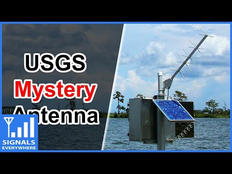
Category: Satellite

NOAA-APT Software Decoder: Users Guide Now Available

Back in August, 2018 we posted about NOAA-APT, which back then was a new NOAA APT image decoder program. Recently Martin, the author of NOAA-APT has written in and wanted to note that he's now created a guide and video tutorials for his software, and for NOAA APT reception in general.

NOAA weather satellites broadcast an Automatic Picture Transmission (APT) signal, which contains a live weather image of your area. With an RTL-SDR and antenna they can be received and downloaded every time one of the satellite's passes overhead which could be multiple times a day.

Our standard NOAA weather satellite tutorial makes use of SDR#, audio piping and the WXtoIMG to receive NOAA satellite images. Martin's guide and software might be slightly easier for newbies as it only involves recording an audio WAV file, then loading it up into his software. The disadvantage is that the image is not colorized, and not displayed in real time as it is in WXtoIMG.

As you may already know, the old standard software in NOAA image decoding, WXtoIMG, is now considered abandonware, and the only place to get it is from a third party mirror rehosting the now defunct WXtoIMG website. As WXtoIMG is closed source no further development can occur on it. Martin's NOAA-APT still misses a lot of the advanced features of WXtoIMG but it is fully open source and multiplatform, and so it is a very promising program.

Receiving NOAA satellite images with noaa-apt and SDR#

Decoding Es’Hail-2 DVB-S2 Realtime in Linux with LeanDVB

Last week we posted about M Khanfar's YouTube video that showed how to decode Es'Hail-2/QO-100 DVB-S2 on Ubuntu with the LeanDVB decoder. However, the method he showed was not in real time as it involved recording an IQ file in GQRX first, then decoding that IQ file. Similarly we also posted last week about a Windows based real time decoder.

M Khanfar recently wrote in again and wanted to show that real time decoding is possible with LeanDVB. The method is to simply pipe the output of the rtl_sdr command line decoder in LeanDVB, and then into VLC. He notes that his PC isn't actually fast enough to decode in real time without lag, but a modern i5 CPU would work well. The actual terminal command is shown in his YouTube video description.

This is Realtime live DVB-S2 Decoding done , without need to record .RAW file , its live and easy method by one click ! In this video i decoding 2MS symbol rate from wideband transponder of QO-100 beacon , you can decoding 1MS , 0.5MS , 333KS , 125KS symbol rate ! The lower Symbol, the faster speed for decoding! , the Amateurs operators on QO-100 Uplink DATV DVB-S2 at 0.5 , 333 , 125Ks , so its easy to Live Decoding Now ! With very low SNR ! , so the normal SDR can coverage wideband beacon of 2Ms symbol and all Ham uplink ! , if you have an SDR that can coverage 27.5 mb of bandwidth, so you can easy decoding Live a standard commercial satellite channels! But it need a high speed Pc .

QO-100 Realtime Live DVB-S2 Decoding

Receiving Es’Hail-2 DVB-S2 on Ubuntu With LeanDVB

Yesterday we posted about a real time Windows demodulator for receiving amateur TV DVB-S/S2 on Es'Hail-2/QO-100. Recently another YouTube user "M Khanfar" also submitted a video tutorial showing how to decode Es'Hail-2 DVB-S2 on Ubuntu with an RTL-SDR and the LeanDVB decoder.

Khanfar notes that although the LeanDVB decoding method is not real time, his tests show that the LeanDVB method is able to work with a much lower SNR signal compared to the Windows demodulator. The process is to simply capture an IQ file with GQRX, then run LeanDVB on the command line with the recorded IQ file. It will create a TS file that can be played in any media player.

His receiving setup consists of an RTL-SDR, 100cm dish, modified LNB and a home made bias tee that can switch his LNB between horizontal and vertical polarization.

QO-100 DVB-S2 Decoding

Windows Realtime DVB-S Demodulator for Es’Hail-2 & Amateur TV Available

Thank you to Happysat for writing in and noting that over on the Amsat-DL forums user Markro92 has uploaded a realtime Windows DVB-S demodulator with GUI. The demodulator works with the RTL-SDR, HackRF, SDRplay and PlutoSDR support is due to be added soon. Happysat notes the following: 

It can demodulate DVB-S and S2 signals with very low symbolrate on Es Hail-2 geosat on 25,9 East from the Wideband Transponder. So you do not need a modified lnb or modified satelitte stb :) Of course you can also see the amateur tv streams which people uplink theirself.

To see if there is any stream active one can visit the wideband WebSDR and above the stream the info is displayed which parameters in use (symbol rate and mode dvbs(2)) so you can adjust in the Demodulator program. Stream + Chat: https://eshail.batc.org.uk/wb/ .

The latest version of the software will always be always available at http://v.1337team.tk/dvb-s_gui_amsat.zip.

Happysat Decoding a DVB-S2 stream from Es-Hail2 with an RTL-SDR V3.

Weather Satellite Images from Geostationary COMS-1 Received

COMS-1 Geostationary Satellite Footprint
COMS-1 Geostationary Satellite Footprint https://www.wmo-sat.info/oscar/Satellites/view/33

COMS-1 is a geostationary weather satellited operated by the Korean Meteorological Agency (KMA) which was launched back in 2010. It is similar to NOAA GOES satellites as it is also geostationary orbit (@128.2°E - footprint covers all of Asia + AUS/NZ), and so is far away enough to image the entire disk of the Earth at once. Unfortunately, unlike the GOES satellites which have in the past few years become relatively easy for hobbyists to decode, the COMS-1 LRIT and HRIT downlink data is encrypted by KMA. KMA only appear to provide decryption keys to governments, research institutes and large organizations upon request.

However, recently Australian @sam210723 was able to successfully create code to decrypt the key message file and obtain the images. From a previous Twitter post of his, it appears that the encryption keys from the KMA example code are actually valid and can be used without needing to apply for a key.

Sam notes that he'll soon release a full blog post on his results, but for now he has an older post from last year that explains a bit about the satellite and decryption of the LRIT Key. His code is available on GitHub, and in a recent Twitter post he shows some example images that he's been able to receive using an Airspy SDR.

HackSpace Magazine Discusses SatNOGS, Cubesats and More

HackSpace is a monthly magazine dedicated to modern maker projects. This month issue 18 was released and it focuses on space based projects. The HackSpace Magazine is available for free online in PDF form, and physical copies can also be purchased.  There are several interesting articles but one in particular shows us how to set up a SatNOGS ground station with a Raspberry Pi 3, RTL-SDR and a satellite antenna such as a turnstile. 

A problem with low cost satellites like cubesats is that it is difficult to monitor them as data can only be collected when they are passing over a ground station. So in areas with no ground stations data is simply lost. SatNOGS is an open source project that aims to make it easy for volunteers to build and run RF ground stations that automatically monitor satellite data, and upload that data to the internet for public access. SatNOGS ground stations typically use RTL-SDR dongles as the radio.

A related article in the magazine also discusses cubesats, giving an overview of some previous cubesat launches and what sort of payloads are available. A third article under the space topic discusses the Libre Space Foundation which is the team behind the SatNOGS and various other space based projects that aim to democratize space. Readers may also be interested in the articles showing how to build an ISS countdown timer and how to build a Slim Jim antenna.

HackSpace Magazine SatNOGS Article
HackSpace Magazine SatNOGS Article (Excerpt)

Receiving and Decoding the NAVIC (Indian GPS) Satellites

NAVigation with Indian Constellation (NavIC) (previously known as IRNSS) is an Indian navigation system consisting of 7 satellites in geosynchronous and geostationary orbits above India. It is intended for both public and military use, with a public resolution of up to 20m, and military resolution of up to 1m. After a few set backs, the satellite constellation was completed in April 2018.

Over on his blog Radiojitter, Priyasloka has put up a post showing how he was able to receive and decode the IRNSS/NAVIC satellites. To do this he uses an RTL-SDR with a GNSS antenna connected, and a modified version of the MATLAB GPS code found in this previous post, and in SoftGNSS. His post first goes through how he was able to decode and receive GPS, then goes over the technical details of the NAVIC signal, and then shows some result screenshots where he was able to determine his location with both GPS and NAVIC.

Priyasloka writes that he hasn't uploaded the modified code yet, but he plans to do so soon.

NavIC positioning results received with an RTL-SDR

NUT2NT+ Crowdfunding: Open Source GNSS RF-to-bits Receiver

Back in May 2018 we first posted about Amungo Navigation's NUT4NT+ project, which is a four channel global navigation satellite system (GNSS) board based on the NT1065 chip. With the right antenna, it is capable of receiving any navigation satellite including GPS, GLONASS, Galileo, BeiDou, IRNSS, and QZSS. With access to multiple satellite systems, the positioning resolution can be down to the centimeter.

Currently Crowd Funding now on CrowdSupply is the NUT2NT+, which is their low cost 2-input GNSS board. Early bird units are going for $250 (12 units left at the time of posting), with the normal price being $320. Compared to their previous legacy version it has an FPGA, TCXO, bias tee and other improvements. They write:

NUT2NT+ hardware is open source, as is the software - giving the user the ability to set a receiver’s modes and frequencies, to capture all signals continuously, and to have complete control over primary processing features.

Several startups and large companies offer proprietary GNSS positioning solutions and even mobile GNSS software-defined receivers. But a closed ecosystem reduces accessibility for an enthusiast or professional developer, and it limits what a user can do with their hardware. We are happy to bring NUT2NT+ to the world as an open source option.

We note that this is an advanced device for developers and experimenters, but the possible applications they write about such as precision positioning for autonomous vehicles and black box logging are quite interesting.

NUT2NT+ with RA125 antenna for precision positioning of autonomous vehicles.

Their higher end four channel input version (which appears to only be for sale via contact on their website at the moment) can be used as a coherent receiver which can locate sources of GPS jamming via an augmented reality app. In our previous post we highlighted how they were able to find the location of the GPS jammer/spoofers famously active around the Russian Kremlin buildings.

XNZR is searching for Moscow GPS Spoofing Anomaly