Category: Satellite

Saveitforparts: Seeing Satellites with the Discovery Drive and Discovery Dish

Over on YouTube, Gabe from the saveitforparts channel has uploaded a video where he tests out his Discovery Drive and Discovery Dish with L-Band feed for creating sky heatmaps of L-band satellites.

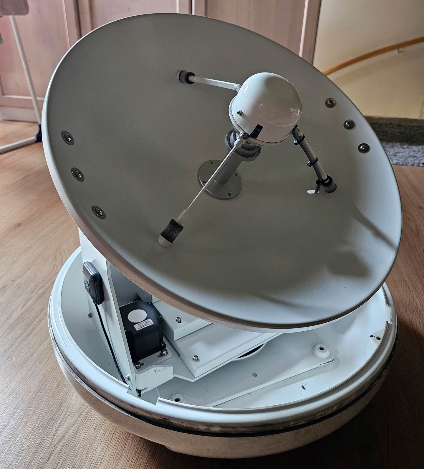
If you were unaware, Discovery Drive is our sister company KrakenRF's most recent successful crowdfunding campaign, which was successfully funded a couple of weeks ago. Discovery Drive is a portable antenna rotator with low power requirements, designed for use with Discovery Dish and other antennas of similar size and weight.

In the video, Gabe writes a custom script that has the Discovery Drive sweep the sky while simultaneously taking RF power readings with the Discovery Dish and L-band feed. The result is an image showing where L-band satellites are in the sky. He goes on to conduct experiments with the hydrogen line and sun imaging, as well as with satellites at UHF frequencies.

Seeing Satellites With The Discovery Drive

SatDump V2 Image Product Expressions YouTube Tutorial

Thank you to Paul Maine, who has submitted a new SatDump tutorial to us that he has uploaded to his YouTube channel. The new tutorial is the fourth in a series focused on SatDump V2.x. In an earlier post, we showed Paul's three previous tutorials.

His SatDump V2.x Part 4 video provides an introduction to SatDump’s “Image Product Expressions”. The video begins with satellite calibration units and descriptions, and includes Albedo, Brightness Temperature, and Radiance. The video then discusses satellite sensors, providing examples. The GOES-19 Satellite and its Advanced Baseline Imager are used in the examples.

Color RGB Images can be created using various satellite bands and Image Product Expressions to produce very beautiful and useful satellite imagery.

Image Product Expression Examples
E 27 SatDump v2.x Part4 Image Product Expressions

L-Band Weather Imagery Soon Coming Back to Western Europe via Elektro-L3

Thanks to weather satellite enthusiast 'Heja Ali' who wrote in to share some welcome news. On February 12, 2026, Roscosmos successfully launched Elektro-L No.5 aboard a Proton-M rocket from Baikonur Cosmodrome, the fifth in the Elektro-L series of Russian geostationary weather satellites (following No.1 in 2011, No.2 in 2015, No.3 in 2019 and No.4 in 2023). Like its predecessors, it carries an unencrypted 1691 MHz L-band downlink with both LRIT and HRIT imagery.

The interesting consequence for amateur satellite enthusiasts is what happens next. Per SatDump's satellite list, L5 is now commissioning at 76°E (L3's old slot), L4 is operational at 165.75°E, and the European slot at 14.5°W is currently held by L2, which has lost its L-band transmitter to a power supply failure. Once L5 is fully operational, L3 is expected to drift west to 14.5°W to replace L2, finally restoring an unencrypted geostationary L-band downlink to the UK, Ireland, Iceland, Portugal, western France, and Spain for the first time since EUMETSAT switched off Meteosat HRIT in 2018.

The Electro-L 1691 MHz signal is easily received by an RTL-SDR Blog V3 or V4, LNA, and a modest 65 cm dish. Our Discovery Dish with the L-band weather satellite feed is a good choice, with existing users in southern Europe routinely pulling Elektro-L3 at 5 to 6 dB SNR using SatDump (which only needs around +1 dB to decode).

There is no firm public timeline yet for L3's drift west, but if you are in far-western Europe and have been waiting on a geostationary L-band satellite to become available, now is a good time to start planning for the receive hardware.

Receiving Electro-L Satellite Imagery With SatDump

Build a Cubesat Reviews a Discovery Drive Prototype and Sets up SatNOGS

Over on YouTube Manuel from the 'Build a Cubesat' channel has uploaded a video testing a prototype version of our Discovery Drive antenna rotator. If you are unaware, Discovery Drive is our new antenna rotator product for applications like satellite tracking and general antenna positioning that is currently being crowd-funded over on Crowd Supply. There are two days left in the campaign.

In the video, Manuel overviews the Discovery Drive, shows the internals, and walks us through the web UI. He goes on to show how it can be set up with the SatNOGS project. The SatNOGS project has volunteers set up ground-based satellite stations, and anyone can use those stations to log an observation anywhere in the world.

We note that he mentioned some trouble with getting SatNOGS to rotate the Discovery Drive over zenith. We have added a note to our Wiki showing how this can be fixed by specifying the correct rotational limits for the Discovery Drive.

Discovery Drive Antenna Rotator Preview

Hacking a Secondhand Marine Satellite Dish to Track Satellites with Gpredict

Thank you to Melan / Alex for submitting news about their project, where they reverse-engineered a second-hand Intellian i4 marine satellite dish, which retails new for around €4000 but which they picked up second-hand for about €200. The dish itself is a 40 cm prime-focus design with a quad LNB, beefy stepper motors, and a motorized sub-reflector implementing Intellian's Dynamic Beam Tilting (DBT) technology, where the small sub-reflector handles fast beam corrections so the main motors only deal with large movements.

The dish normally expects heading data from the boat via NMEA 0183 over RS-422, so Melan solved the "we're not on a boat" problem with an RP2040 and a TTL-to-RS-422 module spoofing $HCHDG compass sentences to the Antenna Control Unit. To avoid being tied to Intellian's Aptus software, they decompiled the C# application to reverse engineer the ACU's text-based serial protocol. They then wrote a shim making the dish appear as a generic rotator to Gpredict, and put it on the roof of Dutch hackerspace NURDspace, pulling in Ku-band satellite TV. 

The full write-up includes photos of the internals, an auto-generated protocol document, and a video of the dish doing a test dance.

The Intellian i4 Marine Satellite Dish Platform

New YouTube Tutorials for SatDump V2.x.x

Thank you to Paul Maine, who has submitted to us new SatDump tutorials that he has uploaded to his YouTube channel. The new tutorials focus on the new SatDump V2.x.x alpha version.

The first tutorial shows how to install SatDump 2.x.x, and how to obtain an EUMETSAT API key and use the 'Load First Party' feature to view and analyze satellite data downloaded from the internet. The second tutorial focuses on the nbew DSP Flowgraph feature, and the third discusses how Look Up Tables (LUTs) are used with satellite imagery.

E24 SatDump v2.x wip Part1

E25 SatDump v2.x wip Part2 DSPflowgraphs

E26 SatDump v2.x wip Part3 LUTs

Using the NISAR Satellite as an Illuminator for Passive Radar

Over on GitHub, Jean-Michel Friedt has uploaded new code, results, and findings from one of his latest experiments with passive radar. A simple passive radar system uses two coherent receive channels and two antennas. One antenna receives a clean reference signal from an illuminator of opportunity, such as an FM or TV transmitter, while the other surveillance antenna receives echoes from the area containing targets. By correlating the surveillance signal with the reference signal over different delays and Doppler shifts, the system produces a range-Doppler map showing potential targets.

The novel thing about Friedt's recent work is that the illuminator is a moving L/S-Band satellite in space. The illuminator used is the polar-orbiting NISAR, a NASA-ISRO satellite designed for synthetic aperture radar (SAR). SAR satellites create detailed images of Earth by sending radar pulses to the ground and combining the returning echoes collected as the satellite moves, effectively simulating a much larger antenna.

Part of the trouble with using NISAR as an illuminator is predicting when it will be illuminating your current location. Friedt's GitHub readme explains how the software does illumination prediction.

NISAR emits chirp signals at 20 MHz bandwidth in the L and S-band, so a wideband SDR is required to get the full resolution. In his setup, Friedt used an Ettus B210 or Enjoy Digital M2SDR SDR, with two active GNSS antennas. 

The results show that he was able to successfully receive reflections of the satellite signal from the ground, transform the range-doppler data into map coordinates, and overlay them on a map.

[Also seen on Hackaday]

Passive Radar via the NISAR Satellite


Ground Station: An Open Source SDR Orchestration Platform for Satellite Tracking and Decoding

Over on GitHub, we've seen the release of a new program simply called "Ground Station", described as a full-featured, open-source software solution for satellite tracking and radio communication.

The software presents as a web-based UI that allows users to manage satellite passes, view SDR waterfall data, decode basic signals such as GMSK telemetry, view telemetry packets, synchronize TLEs, manage multiple SDR devices, browse downloaded weather imagery, monitor DSP performance, and interface with antenna rotators.

Unlike tools such as SatDump, which focus primarily on signal processing and decoding, Ground Station acts as a higher-level orchestration platform. It automates the full workflow, handling pass prediction, SDR control, recording, and decoding, and integrates with SatDump for more complex protocols like weather satellite image decoding.

While SatDump does include some tracking and automation features, Ground Station takes this further with support for multiple SDRs, coordination across multiple stations, and a centralized management interface. It also includes an interesting AI-based speech-to-text feature for transcribing amateur satellite voice communications.

This could be a great tool to use alongside our Discovery Dish and Discovery Drive antenna rotator!

Ground Station: The Overview Page