Tagged: GPS

Decoding Differential GPS Beacons with an RTL-SDR, Speclab and SDR#

Over on his blog “RTL-SDR DX” dewdude has been exploring the reception and decoding of Differential GPS (DGPS) signals. DGPS signals are transmitted by government authorities in the long wave band at around 300 kHz. These beacons are used to dramatically improve the accuracy of GPS (Global Positioning System) devices from their default accuracy of about 15 m down to about 10 cm. Unlike GPS signals which originate from satellites, the DGPS signal is terrestrial based and is broadcast from multiple known fixed positions. The signal itself contains information about the difference between the DGPS stations received GPS position and it’s known exact position. These differences can be used to correct other GPS receivers that receive DGPS signal.

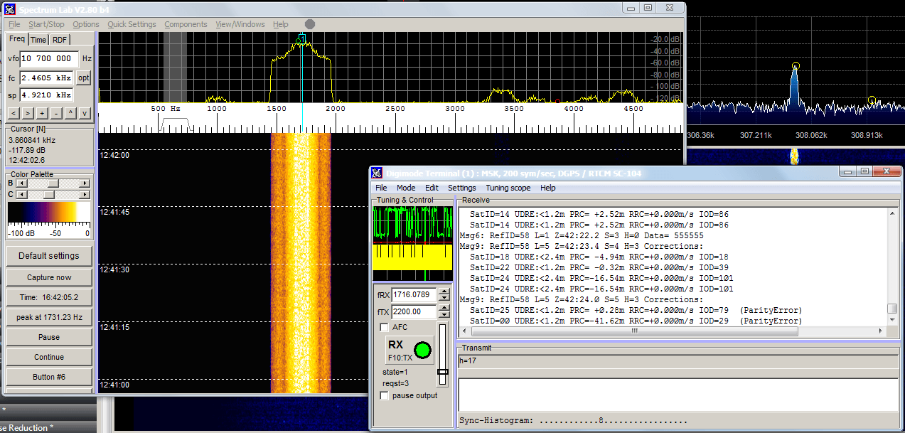
By using his RTL-SDR (with upconverter or HF modification) dewdude was able to receive the DGPS beacon in SDR#. Then by piping the output audio into SpectrumLab’s DGPS decoder he was able to decode the data contained within the DGPS signal. His post contains a tutorial showing how to set up SpectrumLab to decode DGPS. If you’re interested in hearing what a DGPS signal sounds like, dewdude has uploaded a sound sample at the bottom of another post of his.

Decoding Differential GPS (DGPS) signals in SpectrumLab

Signal Mapping using RTLSDR Scanner and GPS on an iOS Device

Recently we posted how RTLSDR Scanner has been updated to allow interfacing with a GPS device. This allows you to make signal strength maps by driving around and recording both signal strength and GPS location together.

As most people don’t have a dedicated GPS device, Reddit user soooooil has put together a short guide on how he was able to use his iPhone as the GPS device and interface it with RTLSDR Scanner.

RTLSDR Scanner with iOS GPS device.

RTLSDR Scanner Now Supports GPS for Signal Strength Mapping

The RTLSDR scanner software has been updated and now supports connection to an external GPS receiver. With a GPS receiver attached to a laptop, the RTL-SDR can be used to make signal strength maps by driving around in a car and monitoring the radio spectrum with RTLSDR Scanner running. The signal strength map can then be viewed in Google Earth, a GIS program or any image viewer.

RTLSDR Scanner GPS Signal Strength Heatmap

GNSS-SDRLIB: Real Time GPS Positioning with RTL-SDR

Over on YouTube user taroz1461 has posted a video showing an RTL-SDR getting a real time GPS location fix using his GNSS-SDRLIB software package. Taroz1461 used an RTL-SDR modified with a temperature controlled oscillator (TCXO) to improve the frequency stability of the dongle.

In the video description he writes that GNSS-SDRLIB will soon have RTL-SDR support in the next update.

GNSS-SDRLIB: Real-time positioning with RTL-SDR (DVB-T Dongle)

GPS Tracking with a modified TCXO RTL-SDR

Michele from Michele’s GNSS blog has posted his results with using a modified R820T RTL-SDR with Temperature Controlled Oscillator (TCXO) for GPS reception and decoding. The RTL-SDR is capable of tracking GPS even without TCXO but improved performance can be expected with a more stable oscillator. He notes that the R820T with it’s 3.57 MHz IF is ideally suited for GPS reception when combined with an active GPS antenna. Using this setup he was able to track GPS satellites and the Galileo E1B/C GNSS satellites as well.

Michele modified his R820T RTL-SDR with a 28.8 MHz TCXO he obtained from a friend. It is however possible to purchase modified TCXO R820T dongles directly from the 1090mhz webstore.

Modified TCXO R820T RTL-SDR used for GPS reception.

Real Time GPS Positioning with the BladeRF

Over on YouTube user taroz1461 shows real time GPS positioning done in software using a BladeRF. The BladeRF is a ~$400 software defined radio which similar specs to the HackRF and compared to the RTL-SDR is capable of receiving much larger bandwidths and transmitting.

To do this decoding he used RTKLIB and his own GNSS-SDRLIB software which is a Windows GUI program. We aren’t sure if this software will work with the RTL-SDR, but we note that other people have had success with GPS positioning and the RTL-SDR.

Real-time GPS positioning with bladeRF

Using the RTL-SDR as a Software GPS Receiver

Dr. Carles Fernandez-Prades, Dr. Javier Arribas and Dr. Pau Closas have published an academic paper showing how they were able to implement an RTL-SDR based GNSS (Global Navigation Satellite System) receiver in software.

What they have done is use their open source GNSS software receiver program with a RTL-SDR connected to an active GPS antenna. An active GPS antenna requires DC power to be passed to the LNA in the GPS antenna through the antenna connection, so a Bias-T network is required to ensure DC power does not enter the RTL-SDR dongle.

More information can be found on their webpage here.

Rtlsdr_with_lna_patch_GA27

Setting up an APRS iGate with the RTL-SDR

Over on Pawel Janowski’s blog (SQ7MRU) a writeup on how to set up an APRS iGate receiver with an RTL-SDR and cubieboard mini computer has been posted. The article has been written in Polish, but can be translated using Google Translate.

APRS stands for Automatic Packet Reporting System and is usually used by Amateur radio operators to broadcast the current GPS coordinates of something such as a transmitter site/car/boat or high altitude amateur balloon. These APRS packets are received by an iGate and then put onto the internet. Check out aprs.fi for an example.

To create an APRS iGate, Pawel runs a RTL-SDR compatible python program called pymultimonaprs which is used to receive and broadcast the APRS data on to the internet.

aprs_fi_rtlsdr