Tagged: weather satellite

Meteor M2-3 Now In Orbit and Transmitting Weather Images

Meteor-M satellites are Russian owned weather imaging satellites that are in polar orbit. They transmit images to earth in the LRPT format at 137 MHz, making them almost as easy to receive as the older NOAA APT satellites. Unfortunately all prior Meteor M satellites have suffered an early ending or partial ending to their mission from technical faults or micro-meteorite collisions.

However, on June 27th 2023 the latest Meteor M2-3 satellite was successfully launched on a Soyuz-2 and has been reported to be already transmitting LRPT images of the earth.
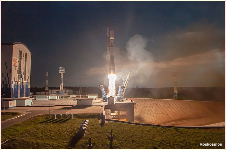
Soyuz-2 Launch of Meteor M2-3 and 42 Cubesats

To receive images from the Meteor M2-3 satellite you will need an appropriate 137 MHz satellite antenna such as a v-dipole, Turnstile or QFH. An RTL-SDR or any similar SDR can be used as the receiver. 

These days, the easiest software to use to receive Meteor M2-3 is probably SatDump, whose Windows and Android binary releases can be downloaded from the GitHub Releases page. Linux users can follow the build guide in the SatDump Readme. We note that we've found the SatDump GUI to run well on an Orange Pi 5, which makes this a good portable solution too. 

To determine when the satellite is over your location you can use satellite tracking software such as Gpredict on Linux and Mac, or Orbitron on Windows. (For Orbitron, remember to run the software as Administrator, and to update the TLEs so that the Meteor M2-3 weather.txt TLE tracking data is downloaded). 

More information about Meteor M2-3's operational status can be found on Happysat's page.

Over on Twitter we've already seen various Tweets about successful reception.

@aang254, the author of SatDump has also noted that he is working on finalizing projections for Meteor M2-3 and this should be ready to use in SatDump shortly.

We also note that a Meteor Demodulator has also now just been added to SDR++.

Another interesting fact is that along with Meteor M2-3 the UmKA cubesat was launched will transmit astronomical images at 2.4 GHz. To receive this, you will most likely need a 2.4 GHz WiFi dish, and also a motorized tracking system to track the satellite as it fly's overhead. Decoding of this is already supported in SatDump according to the programmer.

The Meteor M2 LRPT Weather Satellite has Failed

Meteor M2 is a Russian meteorological satellite whose LRPT transmissions at 137 MHz were relatively easily received by anyone with a simple satellite antenna and an RTL-SDR and computer. Meteor M2 was launched in July 2014, and it should not be confused with Meteor M2-1 which failed on launch in 2017 due to an upper stage deployment issue, or Meteor M2-2 which suffered a micrometeorite strike in 2019.

Unfortunately it appears that Meteor M2 has permanently failed on 24 December 2022. Problems with the Meteor M2 satellite losing orientation stability have occurred several times in the past, and have always been fixed within a few days after the event. There was initially hope that after the holidays when the engineers returned to work that the problem would be fixed. However @Serge, a Russian radio amateur who talks with Meteor engineers on Russian amateur radio forums has recently mentioned on Twitter that recovery seems unlikely.

As well as @Serge's twitter, Happysat keeps track of Meteor M2 satellites on his Meteor M2 status page so keep an eye there for any updates. At the moment all LRPT transmissions have been turned off.

In 2019 the Meteor M2-2 (the third M2 satellite) also failed in December due to a micrometeorite strike. Meteor M N2-2 was partially recovered, and while it can no longer transmit LRPT, it can still transmit HRPT in the L-band, when in sunlight.

The good news is that Meteor M2-3 is due to be launched in 2023, and this will hopefully bring back LRPT reception. Currently the only weather image satellites transmitting at 137 MHz are NOAA-15, NOAA-18 and NOAA-19. NOAA-15 still lives, but may be slowly failing. NOAA-18 and NOAA-19 are also aging satellites but show no signs of wear so far.

If you are interested in satellite reception and want to future proof your setup against more 137 MHz band satellite failures, we recommend looking in LRIT/HRIT or HRPT satellite reception which is a little more complex, but has become significantly easier to get started with in recent times.

Meteor M2 Failure: One of the last LRPT images received by Happysat before it was turned off.

Vitality GOES: A Web Interface for Displaying Weather Images from SatDump and/or goestools

Thank you to Carl Reinemann (aka usradioguy) for submitting his article about Vitality GOES. Vitality GOES is an open source tool that displays the weather satellite images received by SatDump and/or goestools in a user friendly web interface that is accessible over a network connection.

SatDump and goestools are decoders that can be used to decode images from GOES and other satellites, when combined with a PC or single board computer, satellite antenna and RTL-SDR or similar SDR dongle. What they lack however is an easy way to display the received images, as the images are simply dumped to folders. If you're interested in getting started with GOES reception, we have a tutorial here.

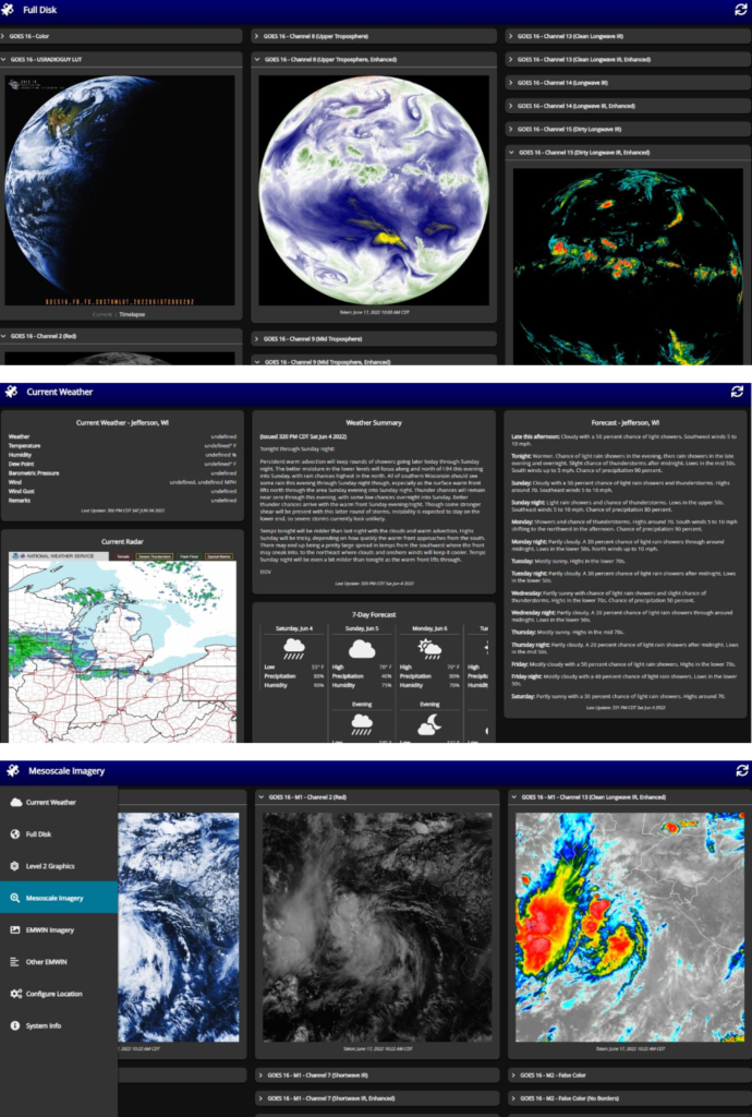
Carl's article explains the purpose of Vitality GOES in detail and shows a few example screenshots. He notes how it can be used to display full disk images, composite together Meteor M2 images, present EMWIN data such as forecasts and warnings, and more.

Carl also notes that Vitality GOES was recently updated to V1.2 with the main update being added support for SatDump. SatDump can decode dozens of different weather satellites, not only GOES, so this opens up a wide range of possibilities.

Vitality GOES - Feature Overview

Vitality GOES: Example screenshots from Carl Reinemann (usaradioguy)

More Information about the NOAA-15 AVHRR Failure

Thank you to Carl Reinmann (aka usradioguy) for submitting his blog post which goes into deeper detail about the NOAA-15 weather satellite imaging failure that we posted about last week. 

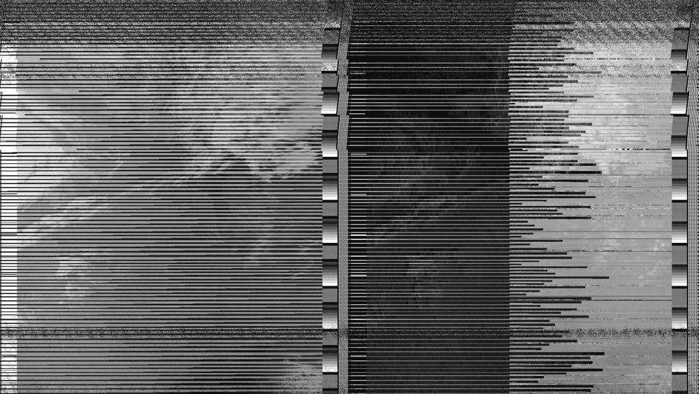
In his post Carl discusses in detail the technical aspects of the AVHRR Scan Motor failure, shows plots of the AVHRR motor current increasing, provides multiple examples of corrupt images being recently received and notes the history of previous failures which were eventually resolved.

He also notes that even with the AVHRR failure the other sensors on the satellite will remain functional, however a failure of this instrument would mean the end of the easy to receive APT images at 137 MHz from NOAA-15. We note that there is still the opportunity to receive NOAA-18 and NOAA-19 which are the remaining operational satellites that transmit APT at 137 MHz.

NOAA have now also released an official notice about the failure which reads:

Product Outage/Anomaly: NOAA-15 AVHRR degraded image data issued by NESDIS NSOF
Date/Time Issued: Oct 22, 2022 1947Z

The NOAA-15 AVHRR Scan Motor current began showing signs of instability on Oct 18 at approximately 1800Z, when the current began to gradually rise from about 205 mA to about 250 mA, where it remained until Oct 24. At about 0000Z on Oct 24, the current began rising again throughout the day, peaking at about 302mA on Oct 25. Scan motor temperature began rising about the same time and is currently steady at ~29°C. The instrument is still producing data, but it is highly degraded. This behavior may be a sign of an impending scan motor stall but requires further investigation. Options for recovery are limited.

NOAA-15 Scan Motor Failure

The NOAA-15 Weather Satellite may be Failing (Again)

The NOAA APT weather satellites are popular because they fly over most places on earth frequently, and they are easy to receive images directly from with modest hardware such as an RTL-SDR and v-dipole antenna.

Three NOAA APT satellites currently operational include NOAA-15, NOAA-18 and NOAA-19. The satellites are however long past their rated mission age, with NOAA-15 being almost 25 years old now.

Unfortunately NOAA-15 appears to be having trouble with it's image scanning motor at the moment, and it is producing corrupted images. This problem has occurred in the past in 2018 and 2019, before fixing itself, so the hope is that it will fix itself again this time.

NOAA does not appear to have released any information about the outage yet on their General Satellite Messages page.

We also wanted to note the recent news that NOAA will be transitioning NOAA-15, 18 and 19 to a private company for on-orbit operations.

Tracking and Decoding Guide for NOAA Weather Satellites

Thank you to Samual Yanz (N7FNV) for submitting a guide that he's created about tracking and decoding NOAA weather satellites. The guide can be downloaded from this link as a PDF. 

Currently there are three operational polar orbiting NOAA weather satellites that transmit image data in the APT format at 137 MHz. When one of these satellites pass overhead, it is possible to use an RTL-SDR with appropriate satellite antenna and software to receive the satellite weather images they transmit.

Samual's guide focuses on the software and shows how to setup Virtual Audio Cable for piping audio between programs, SDR# for receiving the signal, Orbitron for tracking the satellite and WXtoIMG for decoding the image.

SDR#, Orbitron and WXtoIMG

SelfieStick: Combining noisy signals from multiple NOAA APT satellites for clean imagery

Researchers from Carnegie Mellon University have recently presented a paper detailing how they combined noisy signals from multiple passes of low earth orbit (LEO) satellites NOAA 15, NOAA 18 and NOAA 19 in order to create a higher quality image. For a receiver they used a low cost RTL-SDR Blog V3 mounted indoors with a whip antenna.

In a normal setup, weather satellite images from NOAA LEO weather satellites can be received with an RTL-SDR, computing device and an appropriate outdoor mounted antenna that has a good view of the sky. If the antenna is not suited for satellite reception, and/or is mounted indoors, at best only poor quality very noisy images can be received.  

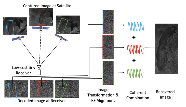
The researchers demonstrate that it is possible to combine noisy images received over time, and from different satellites in order to generate a higher quality image. The challenge is that the different satellites and different receiving times will all produce different images, because the satellites will be at a different location in the sky each pass. They note that simply transforming the images in the image domain would not work very well for highly noisy images, so instead they have devised a method to transform the images in the RF domain. The RF signals are then coherently combined before being demodulated into an image.

The results show that 10 noisy satellite images from the indoor system are comparable to one from a comparison outdoor system. However, they note some limitations in that the system assumes unchanging cloud cover during passes. In the future they hope to extend the system to cover other modulation schemes used by other low earth orbit satellites in order to increase the number of usable satellites.

Selfiestick: Combining noisy images from multiple NOAA satellites received by an indoor RTL-SDR system.

Receiving NOAA Global Area Cover (GAC) Images with LeanHRPT

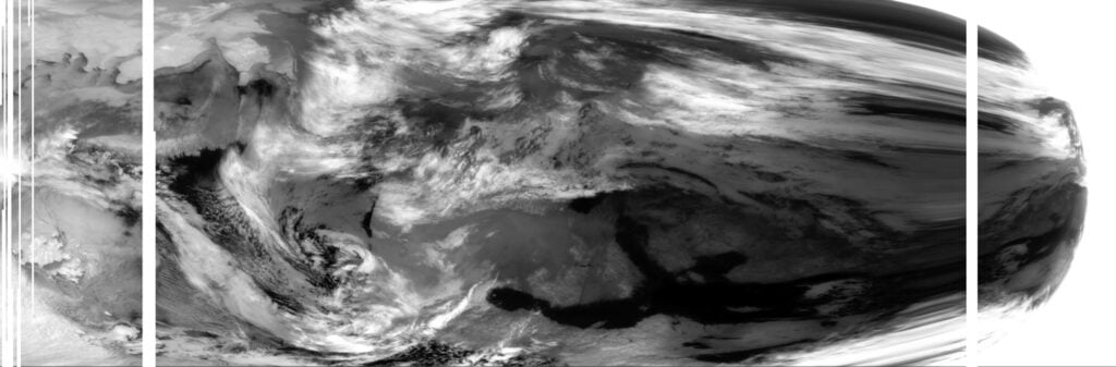
A few weeks ago we posted about how @ZSztanga and @aang254 were able to record and decode Global Area Cover (GAC) images from polar orbiting NOAA weather satellites. GAC images are low resolution, but they provide an image of the entire orbit. The GAC signal is only transmitted over the USA.

A week earlier than @ZSztanga and @aang254 above decoded GAC, another software called LeanHRPT by @Xerbo also implemented a GAC decoder. LeanHRPT is available on Windows, Linux and MacOS, and ready to download binaries are available on the releases page. You'll need the LeanHRPT demodulator too, in order to initially demodulate the signal.

@Xerbo also notes that @dereksgc has also released a useful Python script for predicting NOAA GAC transmissions. It shows when a particular NOAA satellite will begin and end their GAC transmission, as well as the frequency, polarization and elevation of the satellite. 

GAC Transmission Prediction Tool