Tagged: satellite

Using SDR to Investigate Telemetry Still Broadcasting from 1960’s Satellite Transit-5B5

Thank you to Derek @ok9sgc for pointing us to some work Reddit user u/Xerbot has been doing on receiving telemetry coming down from a "dead" 1960's satellite called Transit-5B5. The fleet of Transit satellites was used for military navigation with the first launch in 1959 and the last in 1988. All in the fleet have since died apart from Transit-5B5 which continues to transmit telemetry at 137 MHz when receiving power from in the sun. Derek writes:

Turns out that the TRANSIT 5B-5 satellite's telemetry still has signs of some of the satellite's systems operating (albeit with a questionable reliability). The satellite represents an amazing legacy for all the people that worked on it in the 1950s and 60s, but due to its age it is also very difficult to find technical documentation about the telemetry (or I should rather say impossible), so to make sense of the data that's being broadcast by the satellite would require many people receiving, decoding, and comparing their results, mainly to identify any patterns in the satellite's behavior and the resulting demodulated data.

Derek and u/Xerbot are asking the SDR community to help collect more sample data, which might help in finding a way to decode some of the telemetry. If you have data to contribute, you can contact @ok9sgc on Twitter, and u/Xerbot on Reddit.

This reminds us of an old post from reader happysat where he demonstrated with an RTL-SDR that many "dead" satellites are actually still transmitting telemetry. Due to suspected chemical breakdown of the onboard batteries, the satellites tend to turn themselves on again when the solar panels receive sunlight.
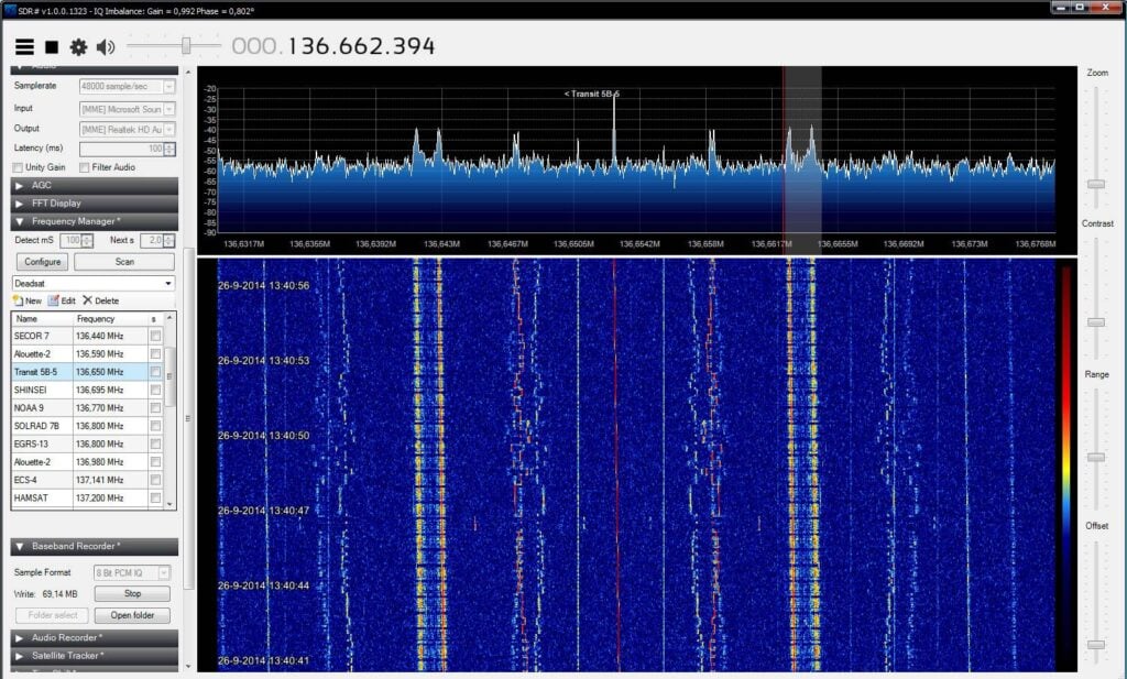
The Transit-5B5 Satellite Telemetry Signal at 137 MHz

Tech Minds: Decoding Orbcomm Satellites with a Software Defined Radio

Over on his YouTube channel TechMinds has uploaded a new video showing how to decode signals from Orbcomm satellites. Orbcomm run a global network of low earth orbit satellites that perform services such as Internet of Things (IoT), Machine 2 Machine (M2M) communications, asset tracking, utilities telemetry, government communications and much more. The signals can be received at around 137 MHz.

In the video he explains how the private client data is encrypted, however it is possible to at least see the encrypted data coming down, and decode some of the data management information such as the transmitted uplink frequencies using a program called Orbcomm Plotter. Ultimately, the data available is quite boring to monitor, however decoding these satellites is still an interesting exercise.

Decoding Orbcomm Satellite Transmissions Using Software Defined Radio

FengYun-2H/G Geostationary Weather Satellite Now Decodable with 120cm Dish (Europe to Australia Coverage)

Hot on the heels of the GOES-13 weather satellite decoder that we posted about a few days ago, @aang254 has just released a new RTL-SDR compatible decoder for the FengYun-2H, 2G and possibly 2E geostationary weather satellites.

The FengYun-2 line of weather satellites are the Chinese equivalents to GOES, and they are positioned to cover parts of Europe, Africa, the Middle East, Asia, Russia, and Australia. So this is another geostationary weather satellite now available to Europeans which broadcasts in the L-Band at 1687.5 MHz. And unlike the weaker GOES-13 L-Band downlink, the FengYun-2 downlink is much stronger which means that reception with a 120cm satellite dish should be possible. We note that it has not yet been confirmed if the typical 90-100 cm WiFi dishes used with GOES-16 and 17 will be big enough to work. @aang254 writes:

Yesterday I successfully decoded the S-VISSR downlink from FengYun-2H thanks to a recording by @MartanBlaho. It is stronger than PDR on EWS-G1 (see Zbychu's signal twitter.com/ZSztanga/statu) meaning it should (untested) be doable with a 120cm (or smaller but no confirmation again) dish instead of 180cm.

It covers parts of Europe, Russia and down to Australia. FY-2G and FY-2E (no confirmation for this one yet) are also decodable in the same way. I released an early decoder, that currently is not suitable for automated setups but allows getting images already. A later version (that should come soon-ish) will allow live decoding / autonomous setups in a similar fashion to other satellites.

Also, the res is 2km/px on VIS and 8km/px on IR, so half that of GOES-13 with similar-ish coverage (Europe is less visible though).

(also forgot to say but the bandwidth is under 2Mhz, allowing a rtlsdr to be used)

https://github.com/altillimity/S-VISSR-Ingestor

FengYun 2H (Left) / 2G (Right) Coverage
FengYun-2H Image Courtesy of @ZSztanga and inverted by @petermeteor

Information about Receiving the GOES-13 Weather Satellite (Europe Coverage with 1.8m Dish)

For some time now many weather satellite enthusiasts have enjoyed the ability to relatively easily receive live high resolution images directly from the GOES-16, GOES-17 and GK-2A geostationary satellites (tutorial here). However, while much of the world can see at least one of these satellites, European's have been left out.

What may be of some interest to Europeans is that the older GOES-13 (aka EWS-G1) satellite was repositioned in February 2020, and it can now be received in Europe (as well as Africa, the Middle East, Asia, Russia and West Australia) until at least 2024 when it will be replaced.

The important catch however is that GOES-13 is not broadcasting the same easy to receive LRIT/HRIT signals that the other satellites use. The signal is still in the L-Band at 1685.7 MHz, however it is called "GVAR" and it is much weaker and uses 5 MHz of bandwidth. For GOES 16/17 and GK-2A a 1m WiFi grid dish, LNA and RTL-SDR was sufficient, but for GOES-13 you'll need a much larger 1.8m dish, and a wider band SDR like an Airspy. The big dish requirement significantly increases the reception challenge.

We also note that the decoder is being developed by @aang254 and u/Xerbot and it is not yet publicly released. However, they do intend to release it soon. Update:

Over on his blog Carl Reinemann has been collecting some useful information about GOES-13 reception. Over on Reddit u/derekcz has also created a post with some useful information. We've also been talking to @ZSztanga in Poland who has been testing this satellite out, he wrote:

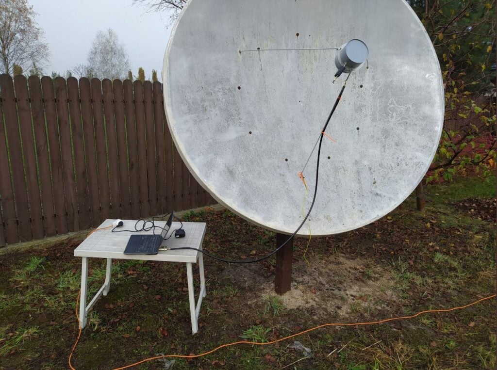
My hardware is: 180cm prime focus dish, with a custom cantenna (120mm diameter). I'm using the SAWBIRD GOES LNA. I will be switching to the + version, because the setup is still lacking a few db SNR. The SDR is the one I use for HRPT: the airspy mini

I found that the USB connection on the airspy generates a lot of noise, so I removed the USB cable, by moving the airspy to the laptop. I use 2m of CNT-400 coax and it works much better now. I get about 2 db SNR more. Thought you might find it interesting.

@ZSztanga's GOES-13 Reception Setup, with 1.8m dish.

We note that there is some interesting differences with GOES-13 images. Since the image is less processed, it is higher resolution (a full resolution image can be found on this Reddit post), as well as not cropped, meaning that the Earth's atmosphere is visible. Please also follow @ZSztang on Twitter for more images.

New GOES Weather Satellite Bundle from NooElec

NooElec have recently released for sale a GOES geostationary weather satellite reception bundle which includes a parabolic grid dish, feed, GOES LNA and RTL-SDR dongle. The bundle should be usable for the GK-2A satellite, as well as HRIT from polar orbiting satellites, although for HRIT you'll need some way to motorize or hand track the satellites.

Typically to receive GOES a 2.4 GHz WiFi grid dish has been used in the past. While the mismatch between 2.4 GHz and the 1.7 GHz used by GOES doesn't cause too much trouble, the dish provided by NooElec has a feed optimized for the 1.7 GHz which should make receiving the signal easier. The bundle also comes with their SAWbird+ GOES LNA, one of their always ON bias tee E4000 tuner based RTL-SDR dongles and a roll of 10m LMR400 cable.

The bundle is currently available on Amazon USA priced at US$179.95. Canadian customers can also order from Amazon.ca for CDN$259.95. Amazon shipping is free within the USA, however shipping this overseas will cost at least US$100 extra due to the weight + additional import fees. That said, the coverage area of GOES is mostly only for the USA, Canada and South America.

If you're interested in GOES or GK-2A satellite reception we have a tutorial written here.

NooElec GOES DIsh
NooElec GOES Bundle Data

Sanchez Scripting Examples For Post-Processing GOES, GK2A, Himawari, Elektro Satellite Images

Recently we posted about new updates to the Sanchez software. The updates allow users to combine images received from multiple geostationary weather satellites such as GOES 16/17, Himawari-8, GK-2A and Electro. The images can also be reprojected into a flat equirectangular image, and then optionally reprojected back into a disk view at any location on earth. Sanchez's original function is also still there which allows users to add a false color underlay image to grayscale infrared images received from the satellites.

Sanchez is a command line tool, so scripts are required to do anything interesting. Over on his page Carl Reinemann has uploaded a page with a number of Sanchez command line examples available. The page shows examples like how to stitch together multiple images, and how to create a stitched time lapse animation. The YouTube video below shows an example of an animation Carl created with Sanchez and GOES 16 and 17 images stitched together.

GOES 16-17 Composite imagery

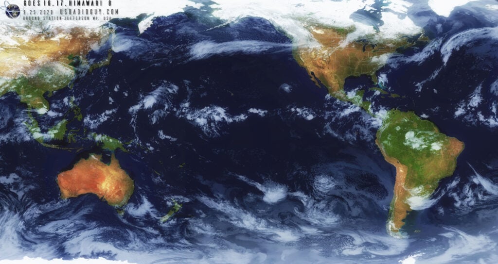
And the image below is an example of an image of Himawari 8, GOES 16 and 17 he stitched together with Sanchez.

GOES 16 and 17 composite created by Carl Reinemann via Sanchez

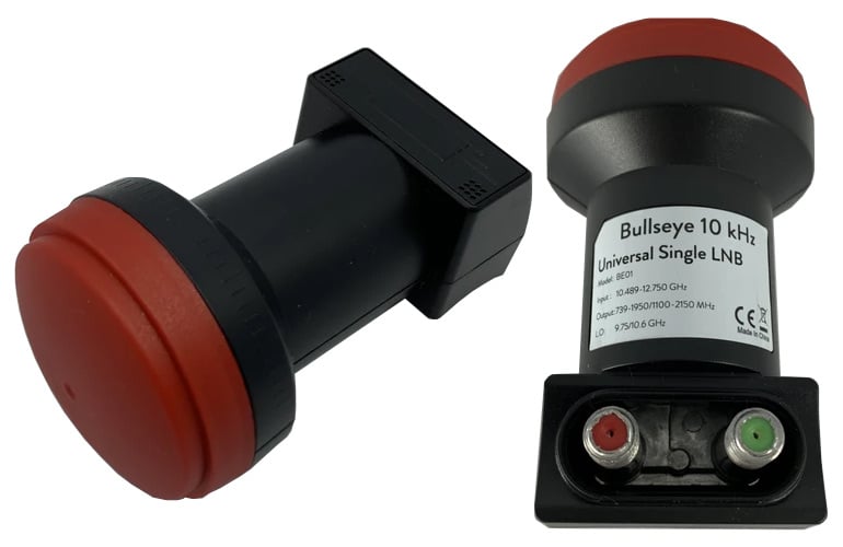
Bullseye TCXO LNB for QO-100 33% Off Sale Ending Soon

On September 15 we began our 33% off stock reduction sale for the Bullseye LNB. The Bullseye is an ultra stable LNB for receiving QO-100 and other Ku-Band satellites/applications. We'll be ending this sale on Wednesday, so if you'd like to purchase a unit please order soon to avoid missing out on the sale price. The current sale price is US$19.97 including free worldwide shipping to most countries. 

To order the product, please go to our store, and scroll down until you see the QO-100 Bullseye TCXO LNB heading. Alternatively we also have stock via our Aliexpress store or on eBay.

For more information about the Bullseye and some reviews please see the original sale post.

The Bullseye LNB for QO-100

Microwave Humidity Sounder Decoder for the NOAA-19 Satellite Released

Back in June we posted about the release of  Zbigniew Sztanga's NOAA-HIRS-Decoder which can decode HIRS instrument data which measures the vertical temperature profile of the Earth's surface. This HIRS signal is broadcast by NOAA satellites at the same time as their APT images and the HIRS frequency is close by at 137.350 MHz. 

Recently Zbigniew has released a new decoder for the Microwave Humidity Sounder (MHS) instrument which is available on NOAA-19 only. This MHS instrument observes the Earth in the 89-190 GHz microwave band, which can be useful for measuring humidity levels. However, unlike the APT and HIRS signals which downlink data at around 137 MHz, the MHS data is broadcast in the L-band within the HRPT signal, so a motorized or tracked satellite dish will be required to receive it. Zbigniew writes:

The MHS (Microwave humidity sounder) is an instrument on NOAA-18 and NOAA-19. It replaced the older AMSU-B. It has a resolution of 90px per line and 5 channels.
 
Data from the instrument is present in HRPT and can be decoded with my new software. Unfortunately, only MHS on N-19 is working, because N-18's NHS is dead.
 
The instrument can be used to monitor low clouds, percipation and water vaopr in the atmosphere. I attached a sample image to the email.
 
It's available on the same repo as Aang23' HRPT decoders: https://github.com/altillimity/L-Band-Decoders/tree/master/NOAA%20MHS%20Decoder
Microwave Humidity Sounder data from NOAA-19.