At the 2019 TAPR Digital Communications Conference (DCC), Corey Shields (KB9JHU) and Dan White (AD0CQ) presented a comprehensive guide on setting up your own SatNOGS satellite ground receiver station. The video of the presentation has just recently been uploaded to YouTube by Ham Radio 2.0.
SatNOGS is an open source project that aims to make it easy for volunteers to build and run satellite ground stations (typically based on RTL-SDR and Raspberry Pi hardware) that automatically receive RF satellite data, and automatically upload that data to the internet for public access. This is very useful for low budget cubesats launched by schools and small organizations who don't have the resources to run a worldwide satellite ground station network. Without global ground stations the majority of data and telemetry collected by the satellite could be lost as it would only pass over the owners ground station once or twice a day with limited time and bandwidth to downlink data. SatNOGS volunteers with distributed ground stations placed all over the world provide a free solution for this problem.
Setting up a SatNOGS station and understanding the data coming down can be a pretty involved project, so Corey and Dan's 3.5 hr presentation gently guides us through the steps required. The guide focuses most on the software side, and does not include information about building their open source Yagi antenna rotator which can be used to receive satellites with lower power weak signals. Instead they focus on using a simpler fixed QFH antenna which is still capable of receiving data from a majority of satellites.
Learn to build and operate your own SatNOGS ground station. The Sunday Seminar is somewhat like the "anchor" topic of the entire weekend of the TAPR Digital Communications Conference. In 2019 we had the privilege of hearing from Corey, KB9JHU and Dan AD0CQ from the SatNOGS Team and they are going to give us, in detail, instructions for setting up a home satellite station.
(2:38) Intro (7:46) Section 1: Satellite Building 101 (1:14:50) Section 2: Using SatNOGS (2:19:55) Section 3: API and Contributing (2:51:55) Section 4: RF Stack and Decoders
SatNOGS Ground Station Building Guide from TAPR DCC 2019
OpenAstroTracker is a recently published open hardware 3D printed tracking mount designed to move DSLR cameras for astrophotography. The mount supports heavy long lenses, so we think that this mount could also have the ability to move long directional antennas for satellite tracking. It could also be interesting to modify it for automatic aircraft photography, similar to what we've seen in this previous post where a Raspberry Pi camera on a pan-tilt mount was used with ADS-B data from an RTL-SDR to track aircraft in the sky with the camera.
The 3D printer files are available on Thingiverse, and the mechanical and electronics build guide, and Arduino code is available on GitHub. The build seems to be quite a bit easier compared to a SatNOGS rotator which is another 3D printed open hardware rotator, but it is yet to be seen what sort of antenna sizes it could rotate.
OpenAstroTracker: Could be modified for satellite tracking.
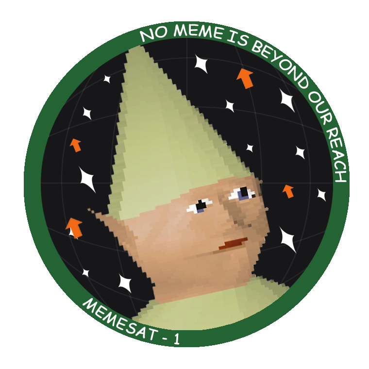
The Mission for Education and Multimedia Engagement Satellite (MEMESat-1) is planned to be the first meme broadcasting cube satellite ever created. If you aren't down with modern slang and are not familiar with the word "meme", that may be because although first coined in 1976, the modern definition was only added to the Webster-Miriam dictionary in 2015. In the traditional sense a meme is a cultural idea, behavior, style that people can't help but want to share because of how funny/amusing/interesting it is.
But in particular MEMESat-1 wants to broadcast from space the new type of meme definition, which is essentially funny or amusing images/GIFs that internet users and especially youth like to modify and share online through social media. Memes have become a major part of internet youth culture, so this could be an excellent way to speak the language of the next generation and get them interested in space, satellites, amateur radio and building satellite ground stations.
At the moment, the team hopes to launch the satellite by late 2021, and no later than Spring 2022. The satellite will be a cubesat with flash memory containing thousands of meme images that will be broadcast to Earth via a transmitter operating in the UHF 70cm radio band. Enthusiasts on the ground will be able to receive the meme images with a Yagi antenna and we anticipate that RTL-SDRs will be a commonly used receiver. The satellite will also contain an FM UHF/VHF repeater operating in the amateur radio band for ham radio use.
I went out and started a nonprofit organization, built a website, developed a meme-related anxiety disorder, and am now building a meme-beaming satellite with a group of undergrads at UGA and some industry sponsors. And it’s all for the sake of making a novel meme. We are now fundraising to launch MEMESat-1.
For those who are interested in reading about the trials and tribulations of a 22 year old man-child trying to send memes into space, I’ve included the longer story below.
For my whole university career, I was in search of different work opportunities and internships to see what felt the most fulfilling and to get some of those sweet sweet resume lines. I’ve interned at a plastic factory, the Air Force Research Labs, NASA JPL, and Ball Aerospace. They were all great places filled with awesome people and cool work, but I didn’t feel connected with my work in a way that fulfilled me. So, for the past 3 years me and my buddies have been joking around about building a satellite that beams down memes from space.
Enter MEMESat-1.
While I was working at JPL, me and some buddies got together to toy around with space start-up ideas. We joked more about MEMESat, and bought the memesat.com domain back in 2018. Due to timing and other life events the start-up idea kind of fell off. One of my pals is pursuing his Ph.D, and the other is working as a spacecraft engineer full-time. I on the other hand, still had 2.5 years of school left.
Work on the MEMESat concept slowly came to a halt by the end of 2018, but picked up again in Spring 2019 when I came up with the acronym the Mission for Education and Multimedia Engagement Satellite (MEMESat-1). I kept telling my classmates and friends about the project idea as a joke, but they thought I was being serious and told me to go for it. By May 2019 I had worked out a deal with some universities to use their space, and began building the website. Over that summer, my job left me some spare time, so I started ramping up the social media for MEMESat-1 by posting daily spacefacts to instagram. I also worked on some preliminary design studies to see if the mission would be feasible, and decided that it definitely was. I also spent the summer researching how to form a company, and what the best company structure would be.
In August 2019, I returned to school and began to work on forming a company. Some great profs at GT gave me the advice to start a nonprofit, so I searched for some pro bono legal advice on starting a nonprofit. I took some of the lawyer’s advice and found some willing Directors for the company, and filed to form a nonprofit corporation - called Let’s Go to Space, Inc.
Around that time, I posted to reddit and got a bunch of attention from you guys, so I figured I should work my hardest to make it happen. I spent months emailing every space related company I could find or even think of. I have much more respect now for people that lead telemarketing campaigns, because it is really hard to convince random people over the phone/email to give you large sums of money. Now, I am happily partnered with Ball Aerospace and sponsored by Blue Canyon Technologies. I’m also in talks with some launch providers about a free launch and some help launching my lesson plans/experiment kits to classrooms all over!
We have passed the point of no return and have nowhere to go but upwards. My parents are confused and slightly disappointed that their rocket scientist son has given up any sort of salary in an effort to appease his ‘internet friends’. God bless you magnificent weirdos for keeping me going. Ad Astra Per Memes.
Currently letsgo2space is fundraising and looking for $30,000 to fund the launch of MEMESAT-1. You can either donate any amount or submit a meme for their broadcast database for $1.69 via their website.
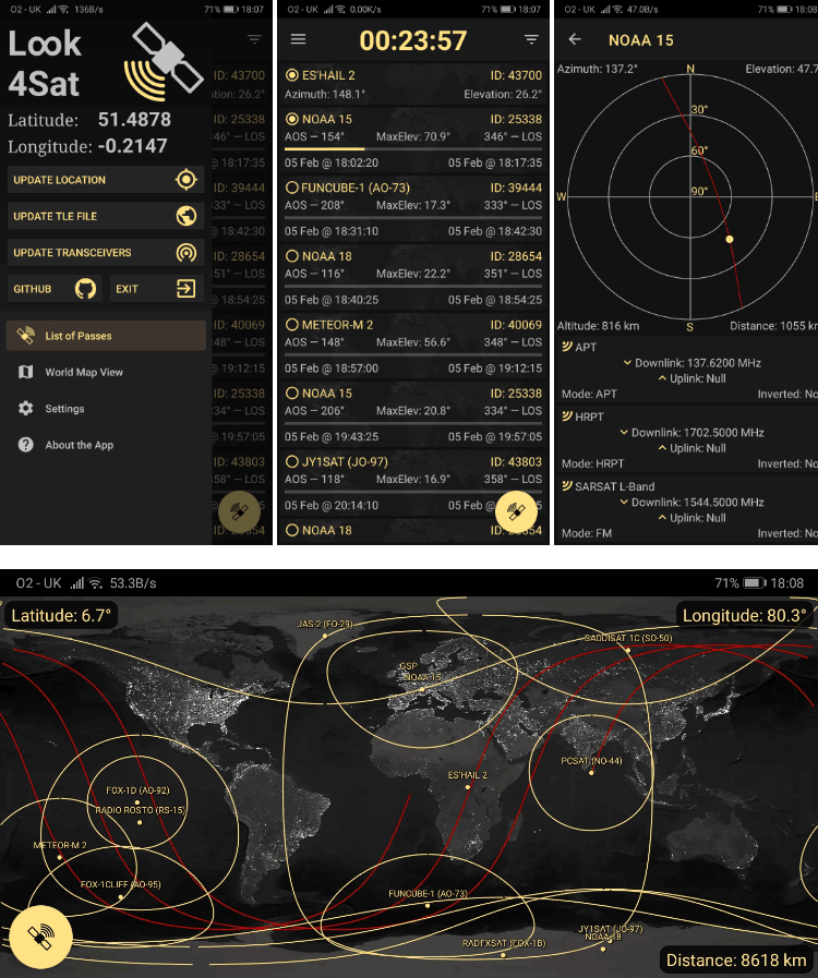
Thank you to Arty Bishop for submitting news about his recently released Android App called Look4Sat. Look4Sat is a satellite tracker and pass predictor with a focus on amateur radio and weather satellites. The app is free, ad free, and open source on GitHub. Arty writes that he's programmed this as a learning exercise and notes:
I always wanted to have an offline and not bloated satellite tracker on my phone, as carrying the laptop at all times is kinda not too handy.
The app uses predict4java library under the hood and is written in Kotlin. The TLE files are from Celestrak and the transmitters info is from SatNOGS and once they are ownloaded the app doesn't need an internet connection.
The app creation and design is hugely inspired by Gpredict which is an absolutely brilliant piece of software. Thank you, Alexandru!
Obviously there is no ads and it's totally free. Hope more people find Look4Sat useful.
The features include:
Calculating satellite passes for up to one week (168 hours)
Calculating passes for the current or manually entered location
Showing the list of currently active and upcoming satellite passes
Showing the active pass progress, polar trajectory and transceivers info
Showing the satellite positional data, footprint and ground track on a map
Offline first: pass prediction is done offline. It's up to you to decide when to update the TLE file and the transceivers DB. (Updates once a week are recommended)
In late December 2019 we posted about Russian weather satellite Meteor M N2-2 which had unfortunately been struck by a micro-meteorite on Dec 18, causing it to lose control and go offline. Meteor M N2 and N2-2 satellites are often monitored with RTL-SDR dongles as it is relatively simple to receive their LRPT signal at 137 MHz which contains a high resolution weather satellite image.
Recently Happysat updated his Meteor M status page, noting that Meteor M N2-2 has been partially recovered, but due to low power it can no longer transmit a 137 MHz LRPT signal ever again. However, the L and X-bands are transmitting while the satellite is in daylight. Happysat writes:
January 2020 There will be only short-term power-ups in the radio visibility zone, and the battery life will be reduced tenfold.
Of particular concern are the batteries they are very quickly overheated and switching from regular to backup.
Unfortunately the power supply features do not allow the 137 MHz transmitter to be used in abnormal power, mode (from solar panels) which is used now although technically it is working fine.
There will be no LRPT Transmission's anymore.
The older Meteor M N2 satellite remains operational transmitting at 137.100 MHz.
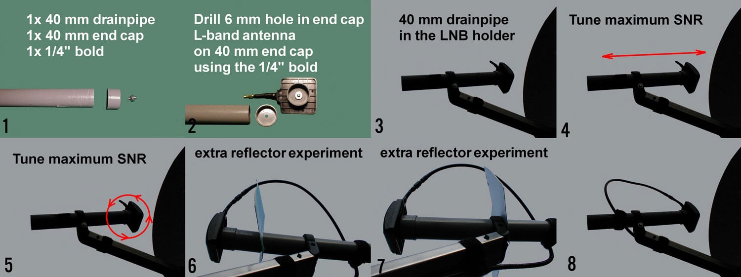
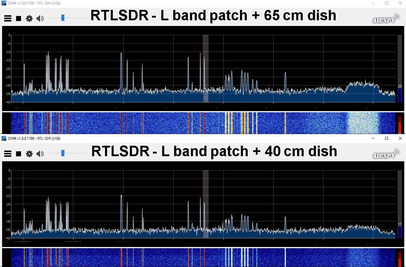
Recently RTL-SDR.COM reader Bert has been experimenting with our active L-band patch antenna product. He's written in to share that he's found that using it as a feed for a satellite dish works well to improve SNR on those weaker 10500 AERO signals which Bert found that he could not decode from his location due to insufficient SNR. Our active L-band patch antenna receives signals from 1525 - 1637 MHz and can be used for signals from Inmarsat, Iridium and GPS satellites.
To use the patch as a feed Bert used a 40mm drain pipe and mounted the antenna on the end of the pipe. The drain pipe fits perfectly into the LNB holder, and once mounted the distance and polarization rotation can easily be adjusted for best SNR. He also found that adding a secondary sub-reflector about 17x17cm in size helped to boost SNR by about 3-5 dB too.
Build steps to use the Active L-band Patch with a Satellite Dish
Bert has tested the active L-band patch as a feed on a 65cm satellite dish and a smaller 40cm dish, both with good results.
UPDATE: It has now been confirmed by Roscosmos that the satellite was struck by what is presumed to be a micrometeorite which caused a leak of thermal transfer gas, and hence a sudden orbit change. It seems unlikely that the satellite will begin operations again as the satellite cannot operate it's camera sensors without thermal cooling. Data is being transmit currently on the X-Band, however, it appears to be a stored image only, rather than live images.
On December 18, 2019, an abnormal situation was recorded on the Meteor-M spacecraft No. 2-2 associated with an external impact (presumably a micrometeorite) on its structure.As a result, he changed the parameters of the orbit and switched to a non-oriented flight mode with high angular velocities.
In accordance with the inherent logic of operation, the device stopped fulfilling the target task and automatically switched to energy-saving mode when the on-board systems that were not involved in ensuring its functioning (including all on-board target equipment) are turned off.
After entering into the zone of Russian ground-based controls with the Meteor-M spacecraft No. 2-2, communication was established and work began to restore its operability: damping angular velocities, transferring to the standard orientation, receiving telemetric and target information.
Currently, work is underway with the satellite under the program of the chief designer.Meteor-M No. 2-2 is in an oriented flight; regular control sessions are conducted with it to receive telemetric information and information from target equipment.
Meteor M N2-2 is a Russian weather satellite that was successfully launched into orbit on July 5 2019. Like with the NOAA and Meteor M N2 satellites, it is possible to receive weather satellite images from this satellite with an RTL-SDR (when it is operational).
The older but still operational Meteor M2 satellite has failed several times in it's history too, each time with the satellite entering an unstable tumble. However, each time the satellite was recovered back into full operation after a few days.
Message from Happysat Meteor M-N 2-2.Around 17/18 Dec lost orientation. Spent two days getting him back unther control again. Succeeded today. Now analysis is stil being carrieout before it becomes operational again. Why it came is still unknown. Thanks Alex.
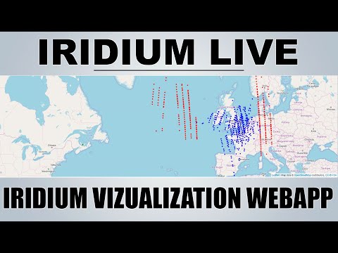
Over on YouTube Tech Minds has uploaded a video of him demonstrating Iridium Live plotting Iridium satellite tracks in real time. We just posted about Iridium Live yesterday. It is a new program by microp11, who is also the author of Scytale-C, a useful Inmarsat STD-C decoder. The software works with gr-iridium to visualize Iridium satellite tracks as they pass overhead.
In the video Tech Minds runs the software on a Raspberry Pi with an Airspy. The current video is only a demonstration, but in the near future he promises to upload a full tutorial
IridiumLIVE - Real Time Visualization Of Iridium Satellites - Raspberry Pi