Category: Satellite

TotalPower: Windows Program for Hydrogen Line Detection and Analysis with an RTL-SDR

Thank you to Mario A. Natali (I0NAA) who wrote in an wanted to share his Windows software called TotalPower which is designed for mapping the galactic Hydrogen line and works with RTL-SDR dongles.

The Hydrogen Line is an observable increase in RF power at 1420.4058 MHz which is created by Hydrogen atoms. It is most easily detected by pointing a directional antenna towards the Milky Way as there are many hydrogen atoms in our own galaxy. This effect can be used to measure the shape and other properties of our own galaxy.

Mario writes:

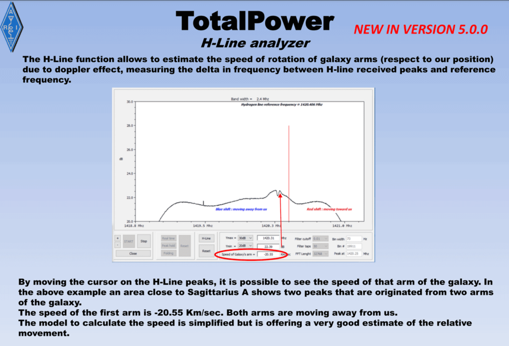
[TotalPower] was originally designed to measure total power of received spectrum and that, thanks to the input of many users, is now able to perform many other tasks including the 3D mapping of selected sky areas and HLine detection with the ability to estimate the speed of rotation of galaxy arms ( respect to our position )

TotalPower is available from the downloads section on Mario's website. Mario has uploaded a manual which explains how the program works, which we have mirrored here.

TotalPower measuring the rotational speed of galactic arms

Modifying a 2.4 GHz WiFi Grid Antenna for Improved 1.7 GHz Reception + DIY Rotator Instructions

People have had much success in receiving L-band weather satellites like GOES and polar orbiting HRPT satellites using 2.4 GHz WiFi grid dishes, even though their 1.7 GHz signals are considered out of band for the WiFi grid dish feed. While this works most of the time, reception can be sometimes weak and borderline.

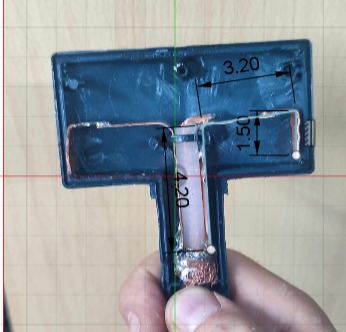
Over on Facebook and usradioguy.com, António Pereira has been sharing his mod which optimizes a 2.4 GHz feed for 1.7 GHz instead. The mod involves removing the enclosure of the feed which requires a heat gun to remove the glue, extending the feed's dipole by soldering on copper extension strips, tuning the dipole with a VNA, and finally tweaking the focal point. This results in an optimized L-band weather satellite antenna.

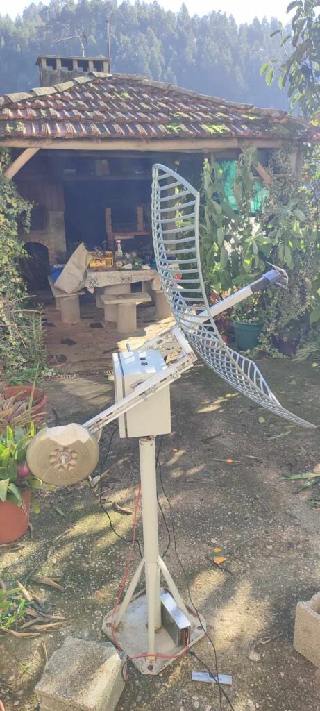
António Pereira has also shared instructions for creating an antenna rotator from an ESP32, Arduino Nano, two NEMA 23 stepper motors, two stepper controllers, two 50:1 worm gearboxes, and two optical homing switches, as well as power supplies for the motors and circuits. He also shares the Arduino code that he's written.

We also note that we currently are crowd funding for our Discovery Dish, which will be a ready to use satellite dish system for L-band weather satellites, as well as Inmarsat and hydrogen line radio astronomy. Check it out on Crowd Supply.

Modified dipole feed on a 2.4 GHz WiFi grid antenna feed
A DIY antenna rotator for the modified 1.7 GHz WiFi grid dish.

Saveitforparts: Building an L-Band Satellite Antenna out of an Umbrella

Over on his YouTube channel "saveitforparts" has uploaded a video where he uses an umbrella, pin tin and tin foil tape to create a simple dish antenna for receiving GOES, NOAA and METEOR HRPT satellites.

The full build consists of an umbrella covered in tin foil tape, a helical wire feed on a pie tin, a filtered LNA, an RTL-SDR and an Android phone running SDR++. While he did have initial success at receiving, he soon decided to swap out the helical wire feed for a PCB linear feed instead which worked much better as helical feeds can be very difficult to get right.

Through the video saveitforparts goes over the failures he had, in the end noting that it's not a great antenna, but it's something that can be used in a pinch.

We've also seen the umbrella satellite dish used a few times in the past, where here it was used for NOAA APT reception, and here for Hydrogen Line radio astronomy.

We also want to remind readers that we are currently Crowd Funding for our Discovery Dish, which will be a low cost way to get into L-band satellite reception.

Can I Get Satellite Data With An Umbrella?

DragonOS: Running GNSS-SDR and Obtaining a GPS Position with an RTL-SDR and Patch Antenna

Over on his YouTube channel Aaron who created and maintains the DragonOS SDR Linux distribution, has uploaded a video demonstrating how to use the GNSS-SDR software together with an RTL-SDR and patch antenna to obtain a live GPS position.

Previously we had only seen a Windows method involving GNSS-SDRLIB and RTKNAVI working as GNSS-SDR on Linux seemed impossible to get running. However, Aaron managed to find a working RTL-SDR configuration for GNSS-SDR which made it come alive. This is great as now GNSS-SDR should be able to run on a portable single board computer like a Raspberry Pi.

The video is a tutorial that shows how to install all the required dependencies, how to compile GNSS-SDR, how to configure it for an RTL-SDR, and how to use it with our RTL-SDR Blog L-band patch antenna.

DragonOS FocalX Setup GNSS-SDR and Obtain GPS Position w/ RTLSDR (Patch Antenna, WarDragon)

Automating NOAA APT and Meteor M2 LRPT Reception with SatDump 1.1.2

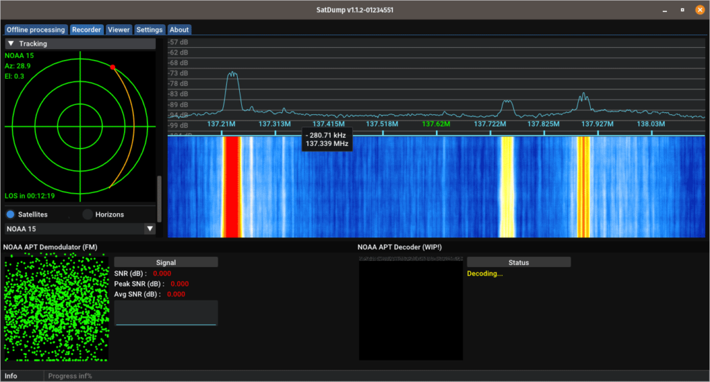
SatDump is a popular program used to receive and decode various forms of weather satellites, and in recent updates they added support for NOAA APT and Meteor M2 LRPT weather satellite decoding. In the latest 1.1.2 release they have also now added support for automation, amongst many other improvements.

Before this update, to automate the reception and decoding of APT and LRPT satellites a Windows PC, and a huge stack of various decoding and tracking programs and SDR# plugins are required, some of which are now even abandonware.

For APT a typical chain was SDR# -> DDETracker -> Orbitron -> WXtoIMG and for LRPT a typical chain is SDR# -> DDETracker -> Orbitron -> LRPT Demodulator -> LRPT Decoder -> SmoothMeteor -> MeteorGIS. Setting this chain of programs up can obviously be a lot of hard work.

The latest version of SatDump adds automation features which means these two entire chains can be replaced with just one program - SatDump. SatDump is available for Windows, Linux and Mac, so it can even run on something like a Raspberry Pi 5 or Orange Pi 5. 

To help users set up automation, @original_lego11 has written up an excellent tutorial that shows how to set the automation up. Automation involves entering your ground station details and selecting and configuring what satellites you want to receive and decode with your RTL-SDR or other SDR hardware.

SatDump 1.1.2 with the new automation features

Discovery Dish Now Available for Crowd Funding! A Lightweight Dish and Feed for L-Band Weather Satellites, Hydrogen Line and Inmarsat

Today our Crowd Funding campaign for the Discovery Dish has gone live! Thank you to anyone who supports this project and our goal of bringing affordable products that make getting into various radio projects easier.

Our launch announcement reads:

We decided to develop Discovery Dish because we were disappointed by the lack of ready-to-use, low-cost, lightweight dish antennas on the market that are suitable for software-defined radio projects like receiving L-Band geostationary and polar-orbiting weather satellites, as well as for 1.5 GHz Inmarsat reception and 1.42 GHz hydrogen line radio astronomy. With excellent open source weather satellite decoding software, like SatDump, now available, it’s time for a complementary, easy-to-use hardware solution.

Through testing over several years, we chose 65 cm as the diameter, as we found that 60 cm is close to the minimum diameter required for perfect GOES weather satellite reception at 24° elevation, so this size should be suitable for most of the world that has GOES reception available. For LRPT satellites like GK-2A, and HRPT polar-orbiting satellites, it is more than large enough. We combined the dish with a carefully tuned feed that has a built-in low-noise amplifier (LNA) and dual filtering, which means there is no loss from feed to LNA. This also means we can use thinner and less stiff coax cable, which is a lot easier to handle and route. Finally we ensured that the entire dish and feed system is waterproof.

The only other ready-to-use dish offering we found is based on a modified 2.4 GHz grid Wi-Fi dish, which is still in our opinion too big and heavy. Size and weight is especially the important if you want to be able to use a low-cost, light-duty antenna rotator, which typically can only handle less than 1 kg in weight. We found that the grid Wi-Fi dish offering also has no solution for waterproofing the LNA, so the LNA needs to be placed indoors and very thick and unwieldy coax is used to avoid feed to LNA losses.

Other ways to receive these weather satellites and carry out hydrogen line experiments typically involve modifying a 2.4 GHz Wi-Fi grid antenna, or an old satellite TV dish. But these modifications can be time-consuming and difficult to get right, and even 60 cm satellite TV dishes are too heavy for light-duty antenna rotators.

Finally, we developed Discovery Dish with an eye toward it being used with a low-cost antenna rotator, and we are in the process of prototyping our own rotator design. Our antenna rotator is not ready for crowdfunding yet, as there are still some things to work out and long-term stress testing to be done, but please keep an eye out for it in 2024! An antenna rotator is a great addition if you want to use a dish antenna to decode images from the polar-orbiting HRPT weather satellites.

Note that you don’t need an antenna rotator to receive geostationary satellites like GOES, or to do drift hydrogen line observations. For polar-orbiting HRPT satellites, the lightweight nature of Discovery Dish also makes tracking the satellites by hand a much easier prospect.

Learn more about Discovery Dish on our main campaign page. Thank you to everyone who supports the Discovery Dish project in any way!
Discovery Dish: Simplified system for weather satellite reception and hydrogen line radio astronomy


SatDump Projections Improved

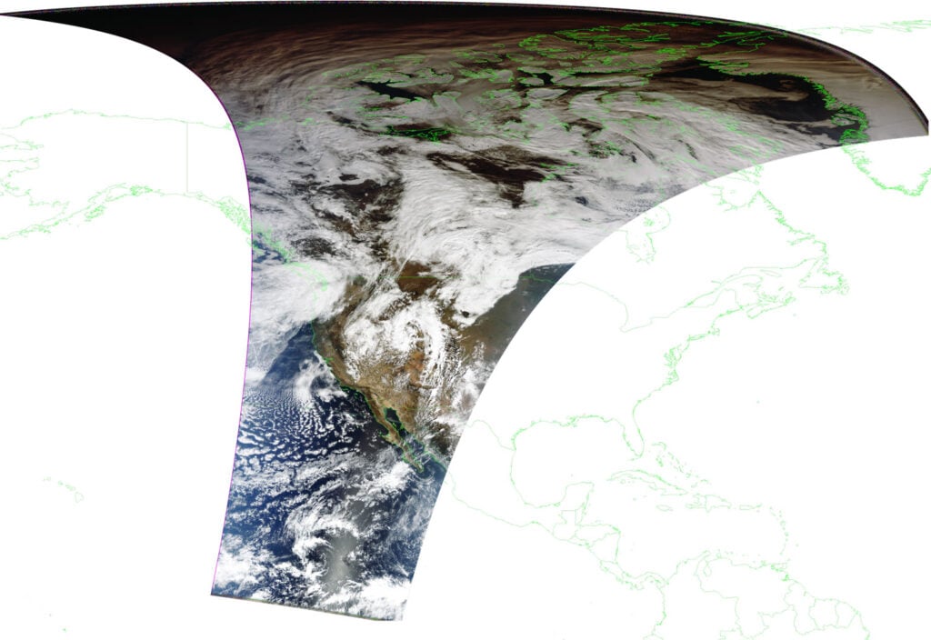
SatDump is a popular program that is used with RTL-SDRs and other SDRs for decoding transmissions from a wide array of weather satellites and their various imagers and sensors. Recently SatDump's author @aang254 has been working on improving the way projections work. Projections are essentially when the weather satellite image is stretched and skewed to fit correctly over the curved earth.

This means now that city markings and border lines should show up in the correct placed in any images received from SatDump.

If you're interested @aang254 has uploaded blog post on the SatDump website explaining the math, algorithms and problems he found when trying to get projections done right.

SatDump now has accurate projections

Repurposing a Wireless networking Dish for L-Band HRPT Satellite Reception

Over on his YouTube channel, "saveitforparts" has uploaded a video showing how he's modified an old wireless networking dish for L-band HRPT satellite reception. L-band satellites that transmit HRPT are polar orbiting, meaning that some sort of tracking solution is required to point the satellite dish at the sky as the satellite passes over. However, lacking any sort of motorized solution, saveitforparts simply removes the dish mount so that the dish can be manually held and tracked.

He notes that he uses the paid version of the Stellarium app for augmented reality tracking of the satellite. In the past there was a great app called "Satellite AR" which did this for free, however within the past few years it has unfortunately been removed from the Google Play store.

The modifications to the dish involve removing the feed from the satellite and installing a custom built helical feed. He also uses a small handheld PC with RTL-SDR on the rear. However in the end the handheld PC turns out to be problematic so he switches to a laptop.

The dish used in saveitforpart's project is quite similar to our upcoming Discovery Dish crowd funding project, so please check that out if you are interested.

Handheld Cyberdeck Dish For Live Satellite Data