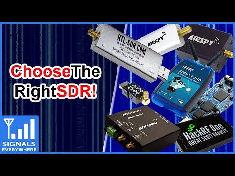
Over on his YouTube channel SignalsEverywhere, Corrosive has just released a new video titled "Software Defined Radio Introduction | What SDR To Buy? | Choose the Right one For You". The video is an introduction to low cost software defined radios and could be useful if you're wondering which SDR you should purchase.
The video includes a brief overview of the Airspy, KerberosSDR, PlutoSDR, LimeSDR Mini, HackRF, SDRplay RSPduo and various RTL-SDR dongles. In addition to the hardware itself Corrosive also discusses the compatible software available for each SDR.
Software Defined Radio Introduction | What SDR To Buy? | Choose the Right one For You
Due to various human activities causing the environmental destruction of it's habitat, the Orangutan is now classed as a critically endangered species. In addition to being endangered, Orangutans face another problem in that they are often captured and sold as pets due to their intelligence and cuteness.
To combat these problems, NGOs, charities and rescue centers have been using RF tags on rehabilitated Orangutans that have released back into the wild. The RF tag regularly transmits a data-less pulse at VHF frequencies which is then typically tracked using direction finding equipment such as a directional Yagi antenna. The range is only approximately 200-400m.
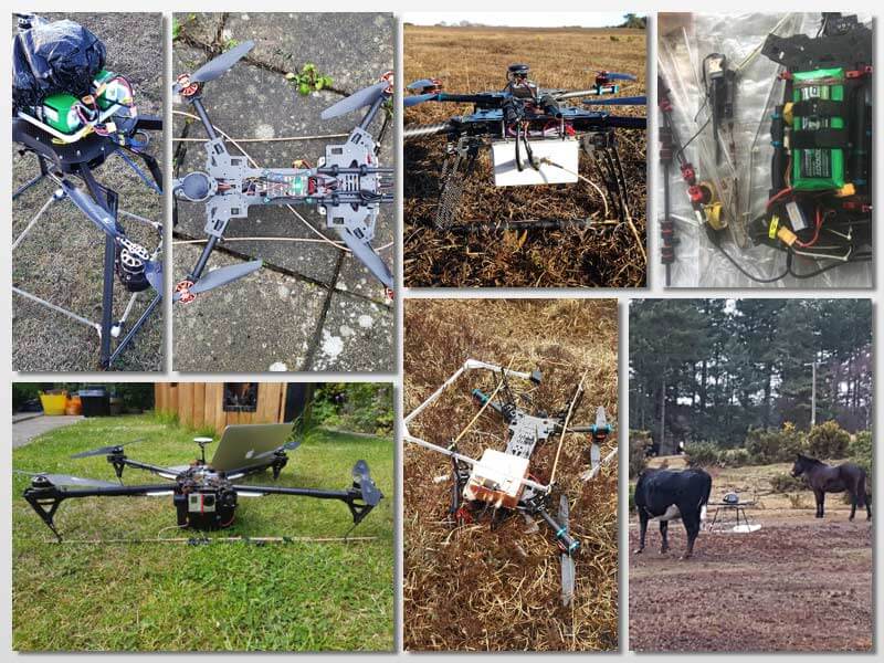
In order to try and alleviate the range issue Dirk Gorissen has been working on creating a drone based system that could detect the VHF transmission and create a heatmap of Orangutan positions. The first iteration of his system uses an RTL-SDR, Odroid and lightweight loop antenna. A simple Python script then monitors the spectrum and logs the drones current location, altitude, speed and heading when a pulse is detected. Tests confirmed that the signal was able to be detected from the sky, but unfortunately the drone was eventually crashed and lost before it could be properly used.
In his second try a few years later, Dirk used a larger drone and switched SDRs to an Airspy Mini with preamp. The pulse detection code was also improved by using GNU Radio to create a DSP algorithm combining peak detection, cross correlation with a known template of the signal, and a phase locked loop. Visualization and data transfer is achieved through react.js and a Flask web server running on the drones WiFi hotspot. This time with the new drone and system Dirk was able to successfully detect and locate several Orangutan's on various flights, despite noting that some RF tags appeared to be glitchy.
Orangutan Detected with Drone, Airspy Mini and GNU Radio.Drone used in the experiment
Hanselminutes is a weekly podcast that aims to promote fresh technology and fresh voices to software developers. Last Friday they interviewed Ben Hilburn who is the project lead and president of the GNU Radio Foundation and Director of Engineering at DeepSig Inc who are working on combining deep learning with the signal processing. In the podcast Ben talks briefly about a broad range of topics like spectrum scarcity issues, different SDR hardware, basic SDR fundamental concepts, multipath, GPS, RF security, analogue vs digital and more. It is aimed at technical people who know little about SDR and radio.
EPISODE SUMMARY
Ben Hilburn is the Director of Engineering at DeepSig Inc., which is commercializing the fundamental research behind deep learning applied to wireless communications and signal processing. He also runs GNU Radio, the most widely used open-source signal processing toolkit in the world, serving as Project Lead and President of The GNU Radio Foundation. Ben talks to Scott about why Software Defined Radio is magical and they talk about how SDR can be used to teach STEM and solve interesting engineering problems.
EPISODE NOTES
Ben Hilburn is the Director of Engineering at DeepSig Inc., which is commercializing the fundamental research behind deep learning applied to wireless communications and signal processing. He also runs GNU Radio, the most widely used open-source signal processing toolkit in the world, serving as Project Lead and President of The GNU Radio Foundation. Ben talks to Scott about why Software Defined Radio is magical and they talk about how SDR can be used to teach STEM and solve interesting engineering problems.
Over on YouTube Andreas Spiess has been helping his friend create a pressure monitoring system for his home brew beer bottles. In order to do this, Andreas uses an externally mounted after market wireless tire pressure sensor whose data can be received with an RTL-SDR and the rtl_433 decoder software. Modern vehicle tires contain a TPMS (tire pressure monitoring system) sensor, which keeps track of tire pressure, temperature and acceleration. The data is wirelessly transmitted via 433 or 315 MHz to the cars dashboard and computer for safety monitoring.
In the first video Andreas discusses tire pressure monitors and how they could be used for other non-tire applications, talks a bit about the wireless protocol used, and how to reverse engineer it. He notes that the author of rtl_433 was able to implement his particular tire pressure sensor brand's protocol into the rtl_433 database, so now anyone can decode them. Finally in this video he also shows that he can easily spoof a flat tire signal using a HackRF and GNU Radio which might cause a modern high end car to refuse to move.
The second video shows how to continuously monitor that TPMS data for the home brew set up. Andreas uses an RTL-SDR and Raspberry Pi running rtl_433, which outputs it's data into Mosquitto, Node-Red, InfluxDB and the Grafana. These programs help to read, manage, log and graph the data. The rtl_433 program is also monitored by Supervisord which automatically restarts rtl_433 if the program crashes.
NOAA weather satellites broadcast an Automatic Picture Transmission (APT) signal, which contains a live weather image of your area. With an RTL-SDR and antenna they can be received and downloaded every time one of the satellite's passes overhead which could be multiple times a day.
Our standard NOAA weather satellite tutorial makes use of SDR#, audio piping and the WXtoIMG to receive NOAA satellite images. Martin's guide and software might be slightly easier for newbies as it only involves recording an audio WAV file, then loading it up into his software. The disadvantage is that the image is not colorized, and not displayed in real time as it is in WXtoIMG.
As you may already know, the old standard software in NOAA image decoding, WXtoIMG, is now considered abandonware, and the only place to get it is from a third party mirror rehosting the now defunct WXtoIMG website. As WXtoIMG is closed source no further development can occur on it. Martin's NOAA-APT still misses a lot of the advanced features of WXtoIMG but it is fully open source and multiplatform, and so it is a very promising program.
Receiving NOAA satellite images with noaa-apt and SDR#
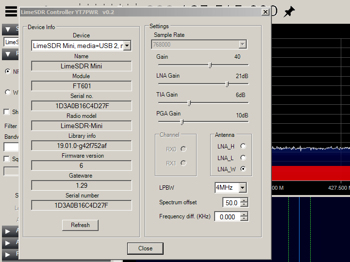
Steve notes that to get the Limesdr Mini to run in SDR# he simply had to download and extract into the SDR# folder a front end plugin developed by Goran Radivojevic (YT7PWR). After adding the front end plugin XML definition, it can now be found in the SDR# device selection menu. This plugin should work for the standard LimeSDR as well.
We note that this is the same procedure for other SDRs too, such as the PlutoSDR. If you have an SDR not supported by default in SDR#, search for "[your_sdr] + SDR# front end plugin" on Google, and if you are lucky you might find something already exisiting.
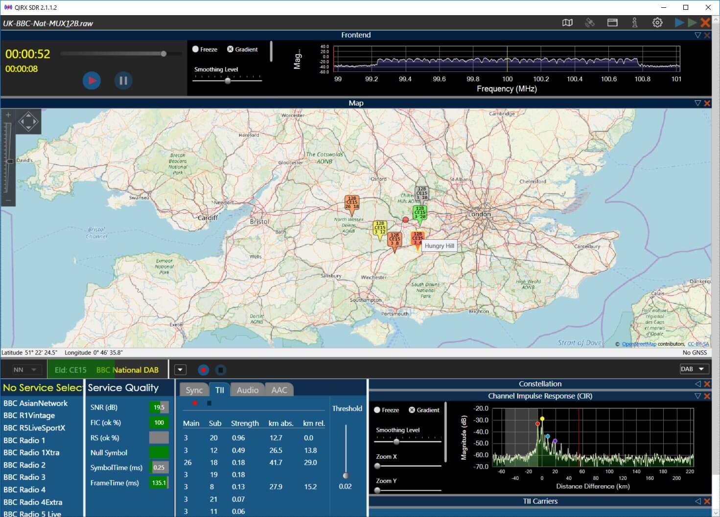
The main new feature is the integration of Openstreetmap to display the locations of DAB transmitters (please see attached picture of a raw recording from England), together with the own position of the receiver.
In case the transmitter ident code (TII) is detected and the transmitter is contained in the database, it is displayed on the map as an icon, colored according to the TII signal strength.
The "Own Position" is indicated as a red or green dot, either (without GNSS sensor) placed by dragging the red circle with the mouse to its correct position, or by attaching a GNSS (GPS or GLONASS) sensor.
When recording raw I/Q data, the GNSS positions are written into a second file, parallel with the .raw file. On replaying, the current recorded geolocation is displayed synchronously to the recorded transmitters on the map. This might be useful in a mobile environment. The distances are displayed in the TII table.
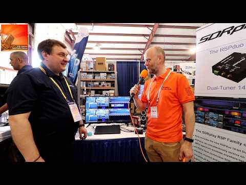
At this years Hamvention Chris Howard from ICQ Amateur interviewed Andy at the SDRplay booth. In the interview they discuss various new features and improvements to SDRuno, the official software for SDRplay devices.
Later they also discuss the RSPduo, and the new diversity feature coming in a new version of SDRUno that is due to be released in a few weeks. The diversity feature works with the two tuners on the RSPduo to combine or subtract signals from two different antennas. Andy notes that diversity should be able to achieve a net 3dB increase in SNR, and is most useful for a moving or dynamic signal environment.
Finally Andy discusses the future development of SDRUno and notes that they're working on a plugin environment which will allow the creation of third party demod/decoders, a multiplatform server for remote SDR, and eventually cross platform drivers and SDRUno.
SDRPlay Announce Update to SDRUno and Future Plans for Software Defined Radio at Hamvention 2019