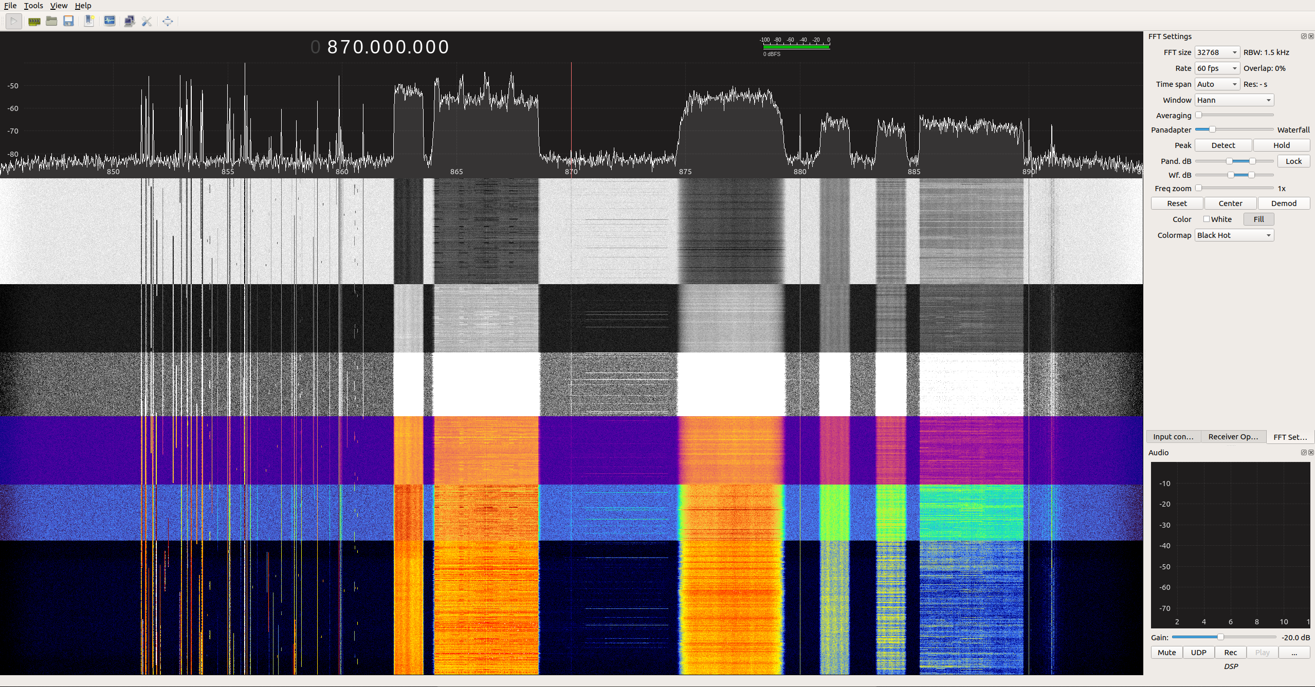
Since mid-January 2020 the popular Linux and Mac compatible SDR program GQRX has seen a number of new code commits over on it's git repository. Some of the updates include moving to GNU Radio 3.8, new color maps, as well as various bug and performance fixes.
At the moment these updates only appear to be available on the latest git code, so to get them you'll need to install GQRX from source via the instructions on the git readme.
Also thank you to @devnulling for providing us with the screenshot posted below which shows off the various new color maps available for the FFT waterfall.
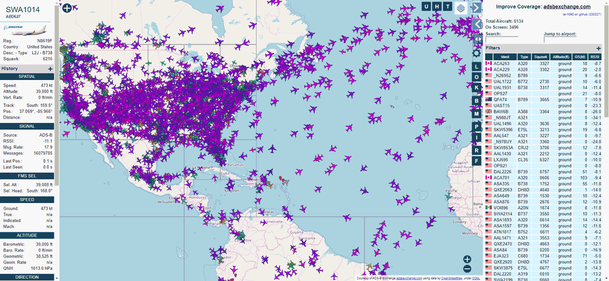
ADSBExchange is an aircraft tracking website service which aggregates ADS-B data from contributors running RTL-SDR's or similar receivers worldwide.
However, unlike other flight tracking sites such as flightaware and flightradar24, ADSBExchange sets themselves apart by proudly refusing to censor the tracking of military and private jets that have requested privacy. One area where this refusal to self-censor helps is with the "Dictator Alert" service. This is a service that automatically tracks the movements of private aircraft owned by authoritarian regimes via the ADS-B data collected and shared by ADSBExchange.
Recently ADSBExchange upgraded their web interface moving from the old Virtual Radar Server system to tar1090 which is a more fully featured open source display for dump1090. This new interface has some great features, like the ability to view the complete flight track history of any aircraft on a particular day, the ability to display only military aircraft and the ability to filter by altitude and aircraft type.
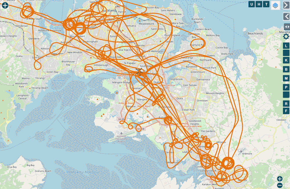
ADSBExchange.com new tar1090 interfaceViewing the historic tracks of 1-day of police helicopter activity in the new ADSBExchange tar1090 interface.
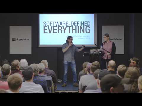
At the Hackaday Supercon Michael Ossmann & Kate Temkin presented a talk called "Software-Defined Everything" where they demonstrated some applications of the "GreatFET One" interface board. Michael Ossmann is best known for creating the HackRF software defined radio which is a highly versatile and low cost open hardware/software SDR transceiver. His company Great Scott Gadgets also employs Kate Temkin who is the lead software developer who worked on their latest product called the GreatFET One.
The GreatFET One is a multi-purpose digital interface board that plugs into a PC via USB. It contains multiple digital IO pins, supports SPI, I2C, UART and JTAG serial protocols, can do logic analysis, and also has a built in ADC and DAC.
In the talk Michael and Kate show how a simple light sensor can be plugged into the GreatFET's ADC, allowing the sensor's data to be digitized and processed in GNU Radio. This results in a software defined light sensor. By analyzing the light data in the frequency domain via an FFT graph they're able to determine the refresh rate of the ceiling lights.
Later they also show how GreatFET can be combined with i2C sensors and GNU Radio to do creative things like use an accelerometer as a microphone for a guitar pickup, with audio effects like guitar clipping controlled by GNU Radio blocks.
Michael Ossmann & Kate Temkin - Software-Defined Everything
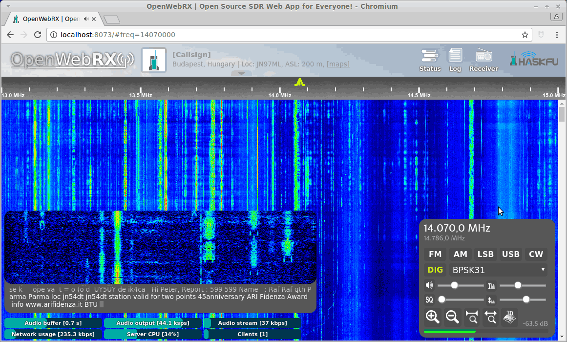
Back in early January we posted about how the popular web based SDR and RTL-SDR compatible receiver software known as OpenWebRX was officially discontinued by the original author. However, thanks to it's open source licence, code contributor Jakob Ketterl (DD5JFK) has been able to continue developing the code and is taking over as the lead developer on his own fork of the code.
Recently he released version 0.18.0 of OpenWebRX which includes a few major upgrades including the much needed shift to Python 3, and the inclusion of multiple new decoders for DMR, D-Star, YSF, NXDN, FT8, FT4, WSPR, JT65, JT9, APRS and Pocsag.
Hello fellow radio enthusiasts,
with great excitement I would like to announce the availability of OpenWebRX Version 0.18.0 as public release. This is the first release of the project in some time, and the first release since I started working on it, so I’m more than happy to bring this to you.
What’s new? Quite a lot, actually. For those that haven’t had the chance to follow the progress of the project in the past months, here’s a quick overview:
Most of the server code has been rewritten for better flexibility, stability and performance. The project is now fully based on Python 3.
Large parts of the frontend code have been updated or polished.
The new core now supports multiple SDR devices simultaneously, as well as switching between multiple profiles per SDR, allowing users to navigate between multiple bands or frequencies.
Added support for demodulation of digital voice modes (DMR, D-Star, YSF, NXDN).
Added support for digital modes of the WSJT-X suite (FT8, FT4, WSPR, JT65, JT9).
Added support for APRS.
Added support for Pocsag.
Bookmarks allow easy navigation between known stations.
Background decoding can transform your receiver into an automatic reporting station, including automatic band scheduling.
The integrated map shows digimode spots as well as APRS and YSF positions.
OpenWebRX 0.18.0 is available via the following channels:
Please check out our updated Setup Guide along with the rest of the documentation on the Wiki!
Questions, ideas, problems? Get in touch with the community at [email protected]!
Best regards and vy 73s
Jakob DD5JFK
We're so glad to see that this excellent software isn't dead in the water and is in fact thriving. We will continue to follow the Jakob's and the OpenWebRX communities' future developments. If you are interested, you can follow OpenWebRX development on the OpenWebRX groups.io forum.
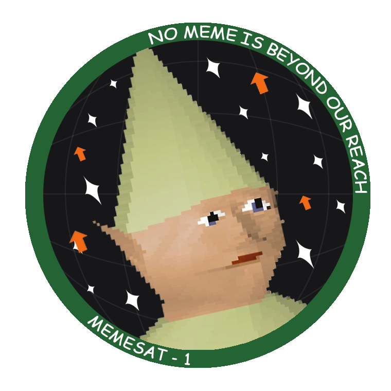
The Mission for Education and Multimedia Engagement Satellite (MEMESat-1) is planned to be the first meme broadcasting cube satellite ever created. If you aren't down with modern slang and are not familiar with the word "meme", that may be because although first coined in 1976, the modern definition was only added to the Webster-Miriam dictionary in 2015. In the traditional sense a meme is a cultural idea, behavior, style that people can't help but want to share because of how funny/amusing/interesting it is.
But in particular MEMESat-1 wants to broadcast from space the new type of meme definition, which is essentially funny or amusing images/GIFs that internet users and especially youth like to modify and share online through social media. Memes have become a major part of internet youth culture, so this could be an excellent way to speak the language of the next generation and get them interested in space, satellites, amateur radio and building satellite ground stations.
At the moment, the team hopes to launch the satellite by late 2021, and no later than Spring 2022. The satellite will be a cubesat with flash memory containing thousands of meme images that will be broadcast to Earth via a transmitter operating in the UHF 70cm radio band. Enthusiasts on the ground will be able to receive the meme images with a Yagi antenna and we anticipate that RTL-SDRs will be a commonly used receiver. The satellite will also contain an FM UHF/VHF repeater operating in the amateur radio band for ham radio use.
I went out and started a nonprofit organization, built a website, developed a meme-related anxiety disorder, and am now building a meme-beaming satellite with a group of undergrads at UGA and some industry sponsors. And it’s all for the sake of making a novel meme. We are now fundraising to launch MEMESat-1.
For those who are interested in reading about the trials and tribulations of a 22 year old man-child trying to send memes into space, I’ve included the longer story below.
For my whole university career, I was in search of different work opportunities and internships to see what felt the most fulfilling and to get some of those sweet sweet resume lines. I’ve interned at a plastic factory, the Air Force Research Labs, NASA JPL, and Ball Aerospace. They were all great places filled with awesome people and cool work, but I didn’t feel connected with my work in a way that fulfilled me. So, for the past 3 years me and my buddies have been joking around about building a satellite that beams down memes from space.
Enter MEMESat-1.
While I was working at JPL, me and some buddies got together to toy around with space start-up ideas. We joked more about MEMESat, and bought the memesat.com domain back in 2018. Due to timing and other life events the start-up idea kind of fell off. One of my pals is pursuing his Ph.D, and the other is working as a spacecraft engineer full-time. I on the other hand, still had 2.5 years of school left.
Work on the MEMESat concept slowly came to a halt by the end of 2018, but picked up again in Spring 2019 when I came up with the acronym the Mission for Education and Multimedia Engagement Satellite (MEMESat-1). I kept telling my classmates and friends about the project idea as a joke, but they thought I was being serious and told me to go for it. By May 2019 I had worked out a deal with some universities to use their space, and began building the website. Over that summer, my job left me some spare time, so I started ramping up the social media for MEMESat-1 by posting daily spacefacts to instagram. I also worked on some preliminary design studies to see if the mission would be feasible, and decided that it definitely was. I also spent the summer researching how to form a company, and what the best company structure would be.
In August 2019, I returned to school and began to work on forming a company. Some great profs at GT gave me the advice to start a nonprofit, so I searched for some pro bono legal advice on starting a nonprofit. I took some of the lawyer’s advice and found some willing Directors for the company, and filed to form a nonprofit corporation - called Let’s Go to Space, Inc.
Around that time, I posted to reddit and got a bunch of attention from you guys, so I figured I should work my hardest to make it happen. I spent months emailing every space related company I could find or even think of. I have much more respect now for people that lead telemarketing campaigns, because it is really hard to convince random people over the phone/email to give you large sums of money. Now, I am happily partnered with Ball Aerospace and sponsored by Blue Canyon Technologies. I’m also in talks with some launch providers about a free launch and some help launching my lesson plans/experiment kits to classrooms all over!
We have passed the point of no return and have nowhere to go but upwards. My parents are confused and slightly disappointed that their rocket scientist son has given up any sort of salary in an effort to appease his ‘internet friends’. God bless you magnificent weirdos for keeping me going. Ad Astra Per Memes.
Currently letsgo2space is fundraising and looking for $30,000 to fund the launch of MEMESAT-1. You can either donate any amount or submit a meme for their broadcast database for $1.69 via their website.
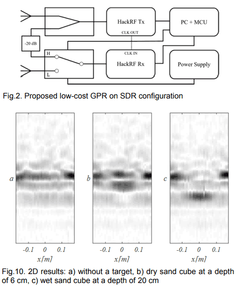
A ground penetrating radar (GPR) is a system that uses RF pulses between 10 to 2.6 GHz to image up to a few meters below the ground. A typical GPR system consists of a transmitting radio and antenna that generates the radar pulse aimed towards the ground, and a receiving radio that receives the reflected pulse.
GPR is typically used for detecting buried objects, determining transitions in ground material and detecting voids and cracks. For example, in construction it can be used to determine rebar locations in concrete, and in the military it can be used to detect non-metallic landmines and hidden underground areas.
Their system uses a step-frequency continuous waveform (SFCW) signal which scans over multiple frequencies over time, and the software was written in GNU Radio. In their tests they were able to detect a dry block of sand buried 6 cm below the ground, and a wet block 20 cm below.
Ground Penetrating Radar with two HackRF software defined radios.
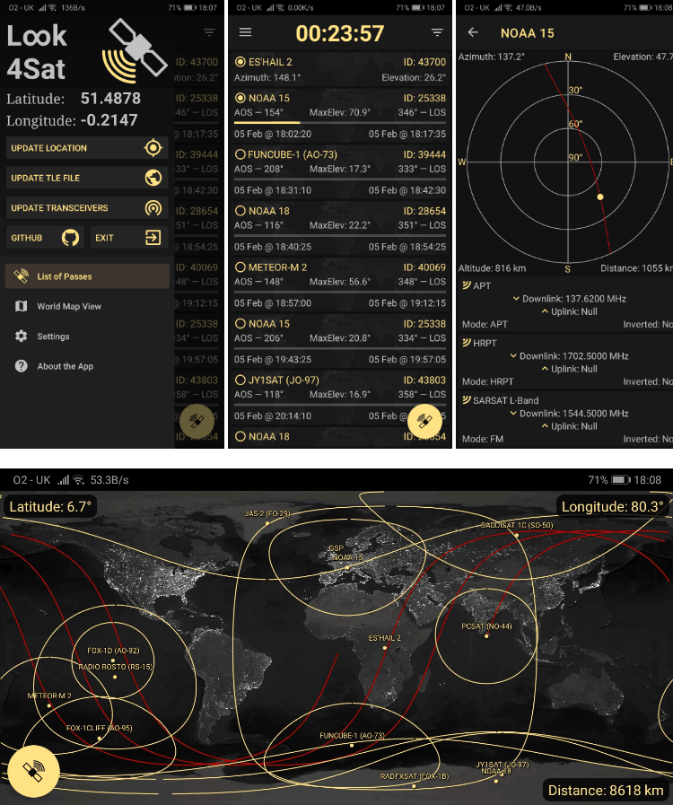
Thank you to Arty Bishop for submitting news about his recently released Android App called Look4Sat. Look4Sat is a satellite tracker and pass predictor with a focus on amateur radio and weather satellites. The app is free, ad free, and open source on GitHub. Arty writes that he's programmed this as a learning exercise and notes:
I always wanted to have an offline and not bloated satellite tracker on my phone, as carrying the laptop at all times is kinda not too handy.
The app uses predict4java library under the hood and is written in Kotlin. The TLE files are from Celestrak and the transmitters info is from SatNOGS and once they are ownloaded the app doesn't need an internet connection.
The app creation and design is hugely inspired by Gpredict which is an absolutely brilliant piece of software. Thank you, Alexandru!
Obviously there is no ads and it's totally free. Hope more people find Look4Sat useful.
The features include:
Calculating satellite passes for up to one week (168 hours)
Calculating passes for the current or manually entered location
Showing the list of currently active and upcoming satellite passes
Showing the active pass progress, polar trajectory and transceivers info
Showing the satellite positional data, footprint and ground track on a map
Offline first: pass prediction is done offline. It's up to you to decide when to update the TLE file and the transceivers DB. (Updates once a week are recommended)
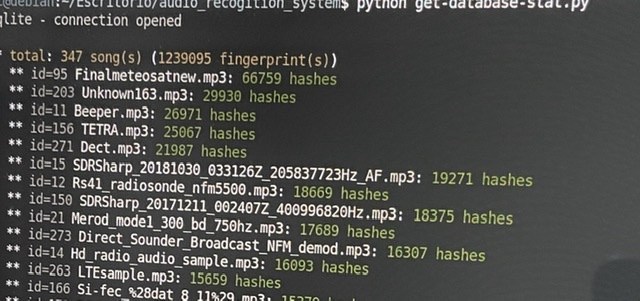
Thank you to José Carlos Rueda for submitting news about his work on converting a "Shazam"-like Python program made originally for song identification into a program that can be used to automatically identify radio signals based on their demodulated audio sounds. Shazam is a popular app for smartphones that can pull up the name of any song playing within seconds via the microphone. It works by using audio fingerprinting algorithms and a database of stored song fingerprints.
Using similar algorithm to Shazam, programmer Joseph Balikuddembe created an open source program called "audio_recogition_system" [sic] which was designed for creating your own audio fingerprint databases out of any mp3 files.
José then had the clever idea to take the database of signal sounds from sigidwiki.com, and create an identification database of signal sounds for audio_recogition_system. He writes that from his database the program can now identify up to 350 known signals from the sigidwiki database. His page contains the installation instructions and a link to download his premade database. The software can identify via audio that is input from the PC microphone/virtual audio cable or from a file.