Thank you to Samual Yanz (N7FNV) for submitting a guide that he's created about tracking and decoding NOAA weather satellites. The guide can be downloaded from this link as a PDF.
Currently there are three operational polar orbiting NOAA weather satellites that transmit image data in the APT format at 137 MHz. When one of these satellites pass overhead, it is possible to use an RTL-SDR with appropriate satellite antenna and software to receive the satellite weather images they transmit.
Samual's guide focuses on the software and shows how to setup Virtual Audio Cable for piping audio between programs, SDR# for receiving the signal, Orbitron for tracking the satellite and WXtoIMG for decoding the image.
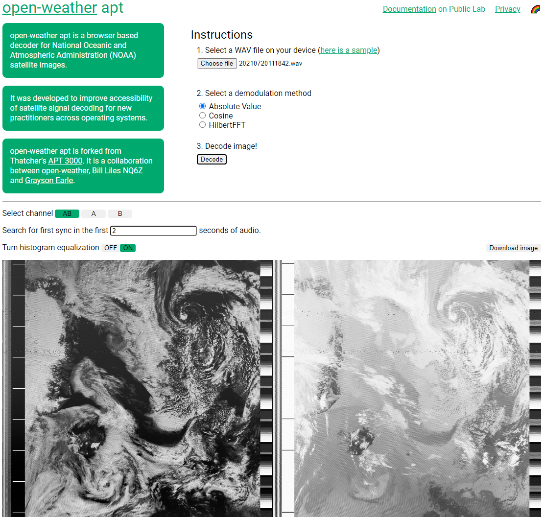
Thank you to Sasha Engelmann for letting us know about the release of the Open-Weather community's web browser based NOAA APT decoder. The decoder allows for easy NOAA satellite decoding by allowing you to upload a wav file recording of a NOAA satellite pass, and it will decode it into an image within the browser.
The project emerged from a desire to understand the process of decoding APT audio recordings into NOAA satellite images, and a need for an accessible browser-based decoder for new practitioners during open-weather DIY Satellite Ground Station workshops.
While we were inspired by Thatcher's APT 3000, we felt accessibility, documentation and features could be expanded and improved. open-weather apt allows you to select an audio file on your computer, choose a demodulation method, add histogram equalisation and download images. The website does not store your personal data, including your location or any files you upload.
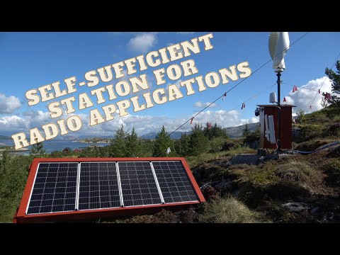
Over on the usradioguy.com blog, Carl Reinemann has highlighted a very impressive remote off-grid radio satellite image receiver setup by Manuel Lausmann (DO3MLA). The setup consists of two Raspberry Pi's, two RTL-SDRs and a QFH satellite antenna connected to an antenna splitter and bias tee. It is able to receive APT and LRPT images from NOAA and Meteor satellites which transmit at 137 MHz. The received images are then uploaded to the internet via a mobile LTE router.
The system is located a remote part of Northern Norway and is powered by a dual solar and wind turbine system with battery storage. Being so remote with little interference, the system is able to receive very clean images, and with the location being so Northern, it can even glimpse the north pole.
Manuel has uploaded a YouTube video where he shows each part of the system. It is in narrated in German, however the YouTube caption auto translate feature can be used.
He notes that in the future he hopes to install a web SDR like KiwiSDR on the site too.
STD-C is a marine satellite service that broadcasts messages that typically contain text information such as search and rescue (SAR) and coast guard messages as well as news, weather and incident reports. With the right software, an RTL-SDR and an appropriate L-Band satellite antenna like our 'Active L-Band 1525 - 1660 Inmarsat to Iridium Patch Antenna Set' these signals can be received and decoded.
The stdcdec software provides a way for command line only systems to receive and view STD-C data. In his video Aaron shows an example setup that uses SigDigger to determine the audio frequency offset, and receive the audio which is then passed to the stdcdec software. We note that SigDigger is a GUI based program but could probably be replaced with another CLI based program, in order to run on a headless system (as long as the tuning and audio center freq is determined before hand). Aaron is hoping to explore solutions for this in the future.
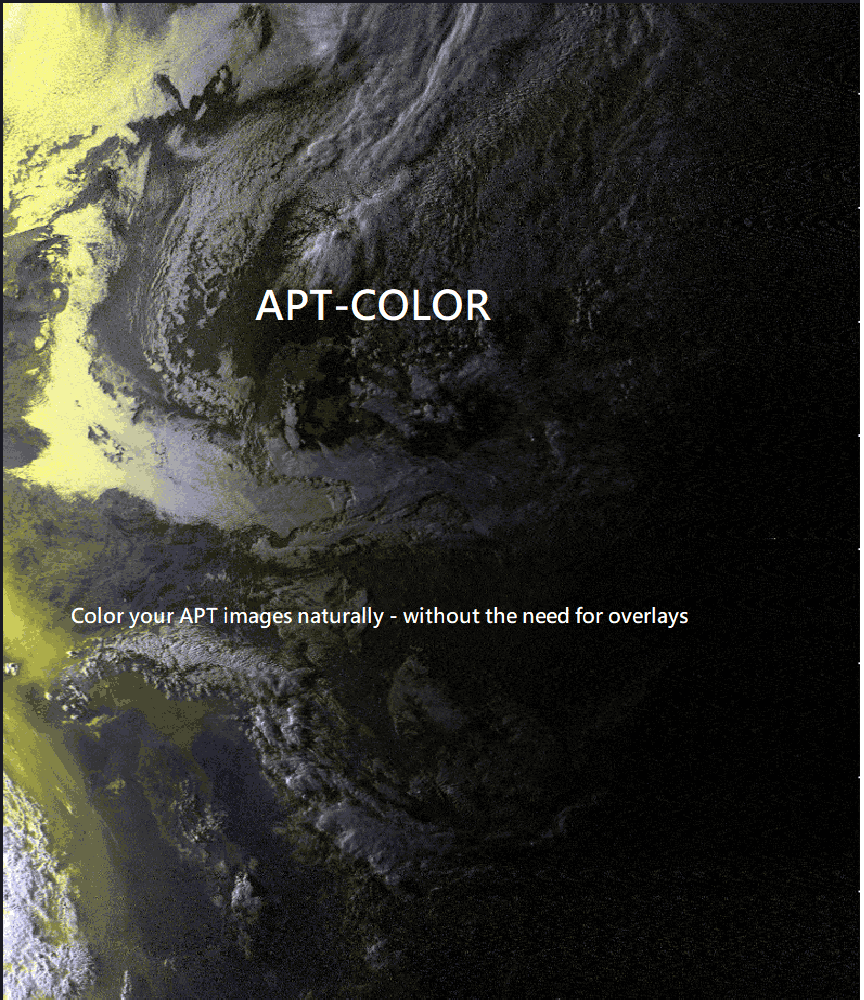
Thank you to Sasha for submitting news about the release of their latest application called "apt_color". The most popular application for decoding APT weather satellite images from NOAA polar orbiting satellites is WXtoIMG. However, WXtoIMG is closed source and is abandonware. There are APT decoder alternatives, however unlike WXtoIMG most other open source APT decoders only provide black and white images, and do not have a false color feature.
The apt_color application can be used to turn black and white APT images received from NOAA satellites into false color images. Sasha writes:
I am working on an APT false color application here. The application is still in the very, very, early stages but still seems to produce good results. It does not need to rely on any overlays, it simply works off the data you give it - the original decoded image data. I will attach some results. NOAA-18 seems to be the best suited spacecraft for this program.
apt_color: Turn black and white NOAA images into false colorapt_color: Examples
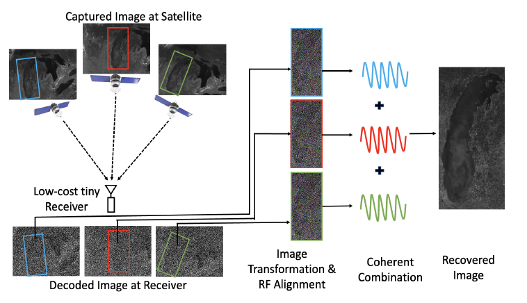
Researchers from Carnegie Mellon University have recently presented a paper detailing how they combined noisy signals from multiple passes of low earth orbit (LEO) satellites NOAA 15, NOAA 18 and NOAA 19 in order to create a higher quality image. For a receiver they used a low cost RTL-SDR Blog V3 mounted indoors with a whip antenna.
In a normal setup, weather satellite images from NOAA LEO weather satellites can be received with an RTL-SDR, computing device and an appropriate outdoor mounted antenna that has a good view of the sky. If the antenna is not suited for satellite reception, and/or is mounted indoors, at best only poor quality very noisy images can be received.
The researchers demonstrate that it is possible to combine noisy images received over time, and from different satellites in order to generate a higher quality image. The challenge is that the different satellites and different receiving times will all produce different images, because the satellites will be at a different location in the sky each pass. They note that simply transforming the images in the image domain would not work very well for highly noisy images, so instead they have devised a method to transform the images in the RF domain. The RF signals are then coherently combined before being demodulated into an image.
The results show that 10 noisy satellite images from the indoor system are comparable to one from a comparison outdoor system. However, they note some limitations in that the system assumes unchanging cloud cover during passes. In the future they hope to extend the system to cover other modulation schemes used by other low earth orbit satellites in order to increase the number of usable satellites.
Selfiestick: Combining noisy images from multiple NOAA satellites received by an indoor RTL-SDR system.
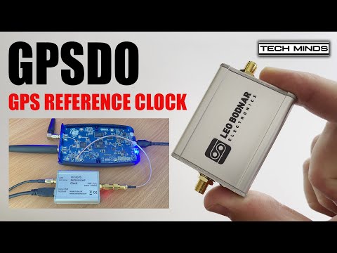
Over on the TechMinds YouTube channel Matt has been experimenting with using a PlutoSDR for QO-100 amateur radio satellite communications. The PlutoSDR is a low cost RX/TX capable SDR with up to 56 MHz of bandwidth and 70 MHz to 6 GHz frequency range (with mods). The PlutoSDR can suffer from frequency instability, especially when warming up, however on the latest model C/D PlutoSDRs it's possible to inject an external clock signal.
In his video experiment, Matt uses a Leo Bodnar GPSDO as an external clock source. A GPSDO is a "GPS Disciplined Oscillator", as it uses the accurate timing information found in GPS signals to create a high quality clock signal. Matt shows how to set up the GPSDO, and how to tell the PlutoSDR to use the external clock.
He goes on to show the effectiveness of the GPSDO with some transmit experiments.
Tech YouTuber Lon.TV has recently uploaded a video demonstrating how to identify and decode various digital transmissions with an RTL-SDR dongle. In the video he explains how to use VB Cable to pipe audio from SDR# into various decoders, and then goes on to show DMR, APRS, POCSAG, L-Band AERO, FT8, and JS8/JS8CALL all being decoded via an RTL-SDR Blog V3 dongle.
Software Defined Radio Part 2 - Decoding Digital Transmissions with an RTL-SDR USB Radio