Category: Satellite

Comparing Home Made Inmarsat Antennas

Over on his blog “coolsdrstuff”, the author has uploaded a new post showing his comparisons of various home made Inmarsat antennas. In his post he tests a tin can helix antenna, a 10-turn helix antenna, and a LHCP helix feed on a 81cm DirecTV dish.

His results show that the dish outperforms the helix antennas by a significant amount, but only once he took it outdoors. The 10-turn helix antenna also worked better than the tin can helix, although he found that it required very accurate pointing.

Inmarsat are geostaionary satellites that transmit signals on L-band at around 1.5 GHz. They transmit signals that can be decoded with an RTL-SDR, such as STD-C EGC (weather, messaging and safety messages for boats), as well as AERO (the satellite version of ACARS for aircraft).

Good Inmarsat reception with the dish.

Decoding the NOAA Weather Satellite Telemetry Beacons

It is well known that the NOAA satellites broadcast weather satellite images which can be received and displayed with an RTL-SDR and computer. What is less known is that there is a telemetry beacon that is also transmitted by the same satellites. The telemetry not only contains data such as the current spacecraft time, day and ID, but also contains scientific data from on board instruments such as:

  • The HIRS/3 and HIRS/4 instruments which is a high resolution infrared sounder which can be used to create a low resolution multi-spectral scan of the earth. (more info)
  • The Space Environment Monitor (SEM-2) which has a Medium Energy Proton and Electron Detector (MEPED), and a Total Energy Detector (TED). This experiment is used to measure the effect of the sun on satellite communications. (more info)
  • The experimental DCS/2 transmitter which retransmits signals from 401.65 MHz sea buoys, arctic fox collars, sea ice monitors, weather balloons and more. (more info pdf)
  • The ARGOS Advanced Data Collection System (ADCS) which amongst other uses is used in research for tracking animal GPS collars around the world.

On GitHub user nebarnix has been working on a standalone C based decoder for these NOAA satellite telemetry beacons. So far from her wiki log, it appears that she has been able to get HIRS decoding and producing an image, receive and graph SEM-2 data, and decode the locations of some fixed DCS transmitters.

A HIRS multispectrum scan of the earth from the NOAA-18 satellite telemetry beacon.

Building a very low cost satellite tracker for your RTL-SDR

A satellite tracker is a motorized unit that points a directional antenna towards passing satellites. Most satellites are not in a fixed orbit, and will fly over your head a few times a day and will be receivable for a few minutes, and a directional antenna is usually recommended since the signals can be weak. The goal of the SatNOGS project is to set up various volunteer satellite tracker stations around the world, and network the received data on the internet, so that satellite data is always being received and shared.

Over on his blog, Paul has written up a tutorial showing how he’s managed to make a super cheap satellite tracker for his RTL-SDR using some pan/tilt servos, a Yagi antenna made from measuring tape, and and Arduino running the SatNOGS tracking software. When he tested the tracker he was able to receive NOAA 18 and some of the XW-2 satellites.

Although the tracker works, he admits that there are some problems and that it is probably not as good as the SatNOGS recommended build, which is a more permanent solution. But the SatNOGS build requires access to a 3D printer and higher quality components, so Paul’s solution is a much cheaper solution to implement at least for experimentation.

The low cost satellite tracker built by Paul.

Satellite Tracker NOAA 18 40x

Receiving Inmarsat L-Band AERO with a DVB-T Antenna, Amplifier and Airspy Mini

To show that a specialized antenna is not required to receive L-band Inmarsat AERO satellite signals, YouTube user SkyWatcher has uploaded a video showing how he was able to receive these signals with a cheap DVB-T antenna. SkyWatcher writes:

I’ve recently upgraded from my RTL-SDR sticks (E4000, R820T2) to an Airspy Mini.

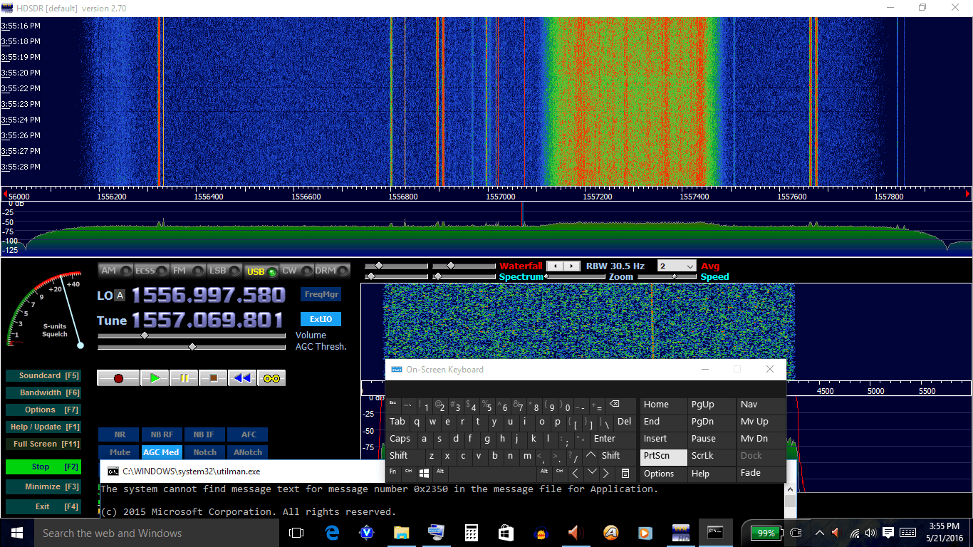
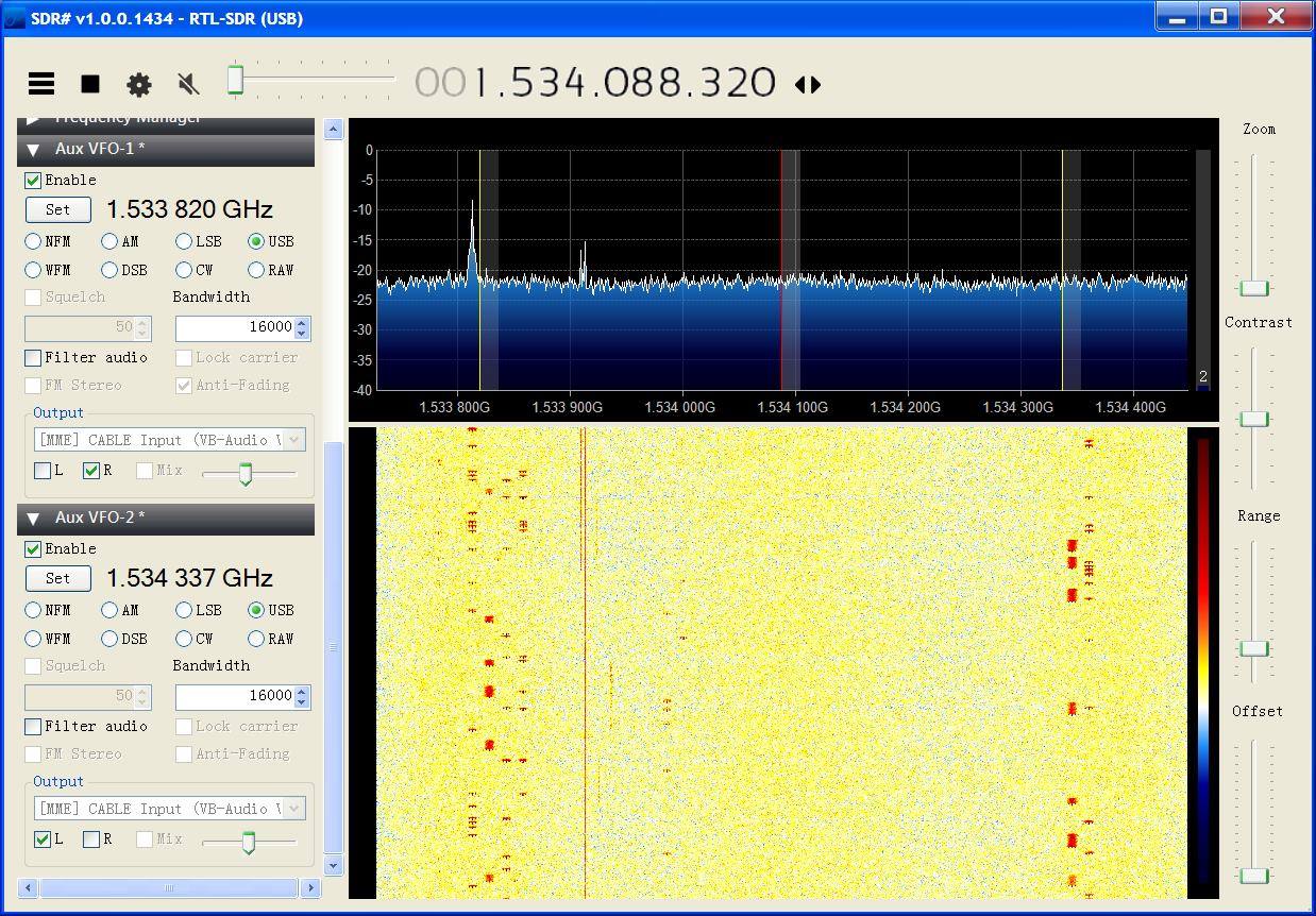
I did some testing during the last week and found it very interesting that I was able to receive Inmarsat L-Band signals indoors, with just a DVB-T antenna and amplifier behind the window, no downconverter, no special antenna, no super low-noise amplifier. The window is facing south, with a few degrees to the east and the satellite I’ve received was Inmarsat 15.43W. So, angle antenna to satellite should be estimated 20 degrees.

I’ve used a 18dB DVB-T/Satellite-TV inline amplifier as a ‘LNA’ (noise < 5dB) and a VHF/UHF DVB-T antenna which seems to be a stacked dipole, and therefore should be quite wideband and should make a reasonable general purpose antenna. Anyway, I did not expect it to work on 1.5GHZ at all. Also, I want to mention that the inline amplifier is rated 5 to 18V, but it works just fine with the 4.5V from the Airspy Mini.

It seems that with 10dB S/N, Aero reception is possible and with about 12dB S/N, it is getting reliable.

In general, I am very satisfied with the upgrade to the Airspy Mini. It has a much lower noisfloor and a much cleaner spectrum, compared to my old RTL SDRs. Also, I am very happy with the CPU-usage which is only about 12% on my i5-3210M when using 2.4MHz bandwith, and 18-20% with a bandwith of 4.8MHz.

Together with the ability to use SpectrumSpy and the very useful decimation-feature, the Airspy Mini is the best option to upgrade from a RTL-SDR for me at the moment. Anyway, of course this is just my very personal opinion… 😉

AERO is essentially the satellite based version of ACARS, and the L-band signals contains short ground to air messages with things like weather reports and flight plans intended to be transmitted to aircraft. To decode it with an SDR, the JAERO software can be used.

Receiving Iridium Satellites with a HackRF Portapack and Cheap Antenna

Recently Jared Boone, creator of the HackRF portapack posted on his blog about his experience with trying to receive Iridium satellite signals. The HackRF is 8-bit, ~0 – 6 GHz, RX/TX capable SDR, and the Portapack is a kit that allows the HackRF to go portable, by adding an LCD screen, battery pack and control wheel. Iridium is an L-band satellite service that provides products such as satellite phones and pagers. Back in December 2014 we posted how it was found that Iridium pager messages could be decoded.

To receive Iridium Jared used a simple ceramic patch antenna mounted on a piece of cheap copper clad fibreglass. This simple antenna was good enough to receive the Iridium signals with good strength. With this set up Jared was able to easily go outside and receive some packets and record them. He writes his next steps are to try and run the Iridium pager decoder on them and see what packets he captured.

Iridium Antenna + HackRF Portapack.


Receiving up to 4.5 GHz with an RTL-SDR and a $5 Directv Downconverter

KD0CQ has recently been experimenting with trying to receive signals at frequencies of up to 4.5 GHz with an RTL-SDR and downconverter. Since a typical R820T/2 RTL-SDR’s maximum frequency limit is about 1.7 GHz, an external downconverter circuit is required. A downconverter converts high frequencies down into the range receivable by the RTL-SDR. For example a downconverter with a 2.4 GHz local oscillator would convert a 3.5 GHz signal down to 1.1 GHz, which can be easily received by an RTL-SDR.

The secret to doing this cheaply is revealed by KD0CQ. He shows that a very cheap $5 Directv SUP-2400 upconverter can be converted into a 2.4 GHz downconverter simply by removing some filters. He writes that he hasn’t uploaded the full set of steps to modify the SUP-2400 yet, but he intends to do so in the near future.

There is also a discussion about this mod on Reddit. Several posters have been discussing what applications a cheap downconverter could open up. Some mentioned applications include receiving various satellites in the C/S bands, DECT cordless phones @ 1.9 GHz, SiriusXM satellite radio @ 2.3 GHz, ISM @ 2.4 GHz, RADARs, RC aircraft control/telemetry/video and ham beacons.

The SUP-2400 Directv upconverter that can be converted into a downconverter.
The SUP-2400 Directv upconverter that can be modified into a downconverter.

$5 Microwave Downconverter for the RTLSDR KD0CQ

Using an RTL-SDR on a high powered rocket to capture GPS data

Over on the SDRGPS blog Philip Hahn and fellow aerospace engineer Paul Breed have been working together to try and use an RTL-SDR to help get accurate GPS data for tracking small high powered rockets. They write that their end goal is to be able to “track high power rockets in high acceleration / speed / altitude environments”.

In their latest attempt they launched a rocket with an RTL-SDR on board with it capturing GPS data to be later processed with GNSS-SDR. The goal was to get a GPS fix throughout the flight. Unfortunately they found that a good fix was only obtained while the rocket was on the ground, and not much data was obtained while it was in the air. They write that they suspect that the fault lies in the vibration in the rocket which can affect the frequency stability of the crystal oscillator, or in the GPS satellite tracking loop algorithm.

They still hope to be able to get some usable information from the flight by trying other algorithms on the data, but they are also seeking advice from anyone who might know how to help them, so please contact them if you know anything that may help.

If you are interested in this, then see our previous post about how Philip showed us how to use an RTL-SDR to receive and plot GPS data.

RTL-SDR + GPS antenna plus an Intel NUC computing platform.
RTL-SDR in aluminum case + GPS antenna + an Intel compute stick and IMU.
The rocket carrying the RTL-SDR.

Recent Updates to the JAERO L-Band and C-Band AERO Decoder

JAERO is a program by Jonti that was released late last year which allows us to use a SDR such as an RTL-SDR to receive L-band and C-Band AERO messages. AERO is essentially the satellite based version of ACARS, and the L-band signals contains short ground to air messages with things like weather reports and flight plans intended to be transmitted to aircraft. The C-band signals are the air to ground portion of AERO and more difficult to receive as they require an LNB and large dish. However they are much more interesting as they contain flight position data, like ADS-B.

Over March JAERO has had some minor updates. It is now possible to display planes on a map by using it’s SBS1 protocol output and outputting the data to Virtual Radar Server. The second more recent update now allows JAERO to simultaneously monitor up to two C-band AERO channels. To do this you will need to use the AUX VFO plugin for SDR#.

If you enjoy JAERO, please remember consider donating to Jonti.

Plotting flights positions out of regular ADS-B range which were demodulated from C-Band AERO signals by JAERO.
Plotting flight positions that are out of regular ADS-B range. Demodulated from C-Band AERO signals with JAERO.
Monitoring two C-Band channels in SDR# with the AUX VFO plugin.