In this episode Corrosive from the SignalsEverywhere YouTube channel begins a series on reverse engineering an old 90's Barbie branded 2.4 GHz wireless camcorder toy, and using it for Amateur Radio TV. The camcorder toy consists of the wireless camera, and a base station that plugs into a TV.
After taking the camcorder apart Corrosive discovered a potentiometer on the PCB which allows the transmit frequency to be adjusted, and that the camera's CCD sensor can actually output composite video, possibly allowing for improved video quality. In addition he found the datasheet for the main FM demodulator chip on board the base station, and saw that it is designed to operate from 350 to 550 MHz. So he speculates that elsewhere in the circuit is a 2.4 GHz downconverter which may be useful for other projects too.
The SDRplay RSPDuo is a 14-bit dual tuner software defined radio capable of tuning between 1 kHz - 2 GHz. It's defining feature is that it has two receivers in one radio, which should allow for interesting phase coherent applications such as diversity.
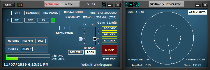
In the latest v1.32 release of SDRUno a diversity feature has been added. Diversity reception was demo'd back in May at Hamvention, and we have a previous post with video about that. Diversity works by subtracting or adding two signals from the two receivers running independent antennas. The result is an up to 3 dB increase in SNR, and better performance with fading signals. They write:
From V1.32 onwards, MRC (Maximal Ratio Combining) Diversity is supported using the RSPduo. MRC Diversity can be used to combine the 2 tuner input streams together to potentially improved the SNR (signal to noise ratio). The same frequency is used for both tuners in the RSPduo and the gain can be adjusted either on each tuner independently or locked together (the default method).
Diversity mode is enabled by clicking on the RSPduo MODE dropdown and select DIVERSITY. Make sure both the 50 ohm ports are connected to the correct input source and note that the HiZ port is not available for Diversity mode. Trying to use the HiZ port will result in an error message being displayed.
On July 5 the Russian Meteor M N2-2 weather satellite was successfully launched into orbit and appears to be healthy. The LRPT weather camera signal is not yet broadcasting however, and we expect it to still take roughly 1-2 months before it begins (if all goes well) as satellites typically run through a long list of qualification tests before becoming operational. During this time there may be broadcasts of test patterns that can be caught. Meteor M N2-2 can currently be tracked in Orbitron and online at N2YO.
To try and dispel any confusion over the naming scheme, "Meteor M N2" is the currently operational LRPT satellite. "Meteor M N2-1" unfortunately failed in 2017 as it did not separate from the rocket. "Meteor M N2-2" is the new satellite which has just been successfully launched. Meteor M N2 and M N2-2 is often abbreviated as just "Meteor M2" and "Meteor M2-2". In the past there was Meteor M N1, but this satellite is no longer operational. We have upcoming launches for Meteor M2-3, M2-4, MP-1 and M3 to look forward to which are scheduled for 2020 and 2021.
Back on June 28 we posted about how Meteor M2 was experiencing orientation issues for a few days. Those issues appear to have been rectified now. Hopefully if M2 remains stable we'll have two Meteor LRPT weather satellites to receive alongside the three NOAA APT satellites.
If you're interested, there were also several other payloads onboard the rocket carrying M2-2, including a low cost Czech experimental cubesat called Lucky7 whose telemetry can be received in the amateur radio band at 437.525 MHz. There is an onboard camera too, but no details on how to receive it yet.
Traditionally when we think about Software-Defined Radio we’re thinking about little USB adapters that unlock a world of radio in the palm of our hands. This is done by allowing us to directly sample the IQ data from the mixer within the SDR.
However, this isn’t the only way to experience Software-Defined Radio. Ham Radio operator [Charlie Morris] has uploaded a 10 part series on YouTube explaining how he implemented his own HF transceiver, including custom software. Some of the components such as the amplifier and filters are built completely from scratch, other components use a little DSP magic from a “Teensy” microcontroller.
Charlie actually samples the I and Q data in a similar way that today’s SDRs do and even implemented the transmit side of the radio so he can make contact with other radio operators around the world, and man… it sounds good!
You can find a complete playlist from Charlie with well-explained videos that go over his entire process from planning, schematics, layout and final operation. The channel appears to be quite active and will surely continue to pump out amazing content.
Homebrew SDR SSB Rig - Part 1 Design Ideas and Thoughts
Thank you to John ZL/KF6VO (creator of the KiwiSDR) for submitting some interesting KiwiSDR related conference talks that might be of interest to some readers. If you were unaware the KiwiSDR is a US$299 HF SDR that can monitor the entire 0 - 30 MHz band at once. It is designed to be web-based and shared, meaning that the KiwiSDR owner, or anyone that they've given access to can tune and listen to it via a web browser over the internet. Many public KiwiSDRs can be found and browsed from the list at sdr.hu or by signal strength and location on this website. One of the most interesting KiwiSDR features is it's TDoA capabilities, which allow users to geographically locate HF transmitters.
Introduction to the KiwiSDR and Bodnar GPSDO
Rob Robinett, AI6VN, gave a talk at the HamSCI Workshop 2019 (USA) “Introduction to the KiwiSDR and Bodnar GPSDO”. In addition to Kiwi basics he shows a live demo of the performance advantages in using an external GPSDO as the Kiwi ADC clock. A line-of-sight measurement of frequency/time station WWV in Colorado using the Kiwi’s internal GPS-compensated crystal oscillator (XO) is compared against using an external Bodnar GPSDO. The Kiwi’s IQ display extension shows the frequency/phase difference between the ADC clock, internal or external, and WWV. Rob also discusses the publicly available (kphsdr.com:8074) eight Kiwi installation he made at coastal radio station KPH north of San Francisco.
Introduction to the KiwiSDR
KiwiSDR as a new GNURadio source and TDoA geo-location
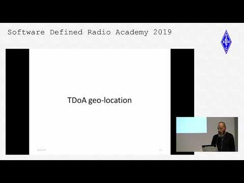
Christoph Mayer, DL1CH, is the author of the Kiwi’s TDoA algorithm. His talk “KiwiSDR as a new GNURadio source and TDoA geo-location” was given at the Software Defined Radio Academy (SDRA) as part of HAM Radio 2019 in Friedrichshafen, Germany. He includes a very technical description of the TDoA process used by the Kiwi including a live demo of direction finding a 16 MHz over-the-horizon-radar (OTHR) signal from Cypress.
Christoph Mayer, DL1CH: KiwiSDR as a new GNURadio Source
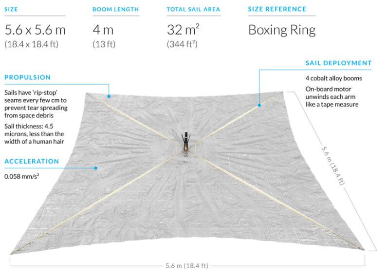
Lightsail-2 is a solar sail experiment which successfully launched on a Space-X Falcon Heavy on 25 June, and was released into orbit on July 2nd. A solar sail is a type of spacecraft that uses a large metallic foil to create propulsion via photons from the sun hitting it. Lightsail-2 is still undergoing testing, so it has not yet deployed it's solar sail, but recent updates indicate that it is healthy.
On board Lightsail-2 is a radio which is transmitting it's morse code beacon "WM9XPA" every 45 seconds at 437.025 MHz. This beacon should be able to be received with a handheld amateur radio 70cm Yagi and any radio such as an RTL-SDR. There is also an AX.25 telemetry data transmission, however although the beacon structure is available we are not aware of any publicly available decoding software.
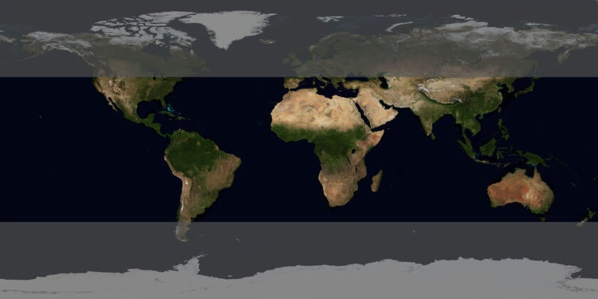
One difficulty in receiving Lightsail-2 is that it is in an orbit inclination of only 24 degrees. So only locations with a latitude between 42 and -42 degrees will have a chance at receiving it. You can see the solar sail's current location at N2YO. Clicking on the 10-day predictions button will give you pass predictions for your location.
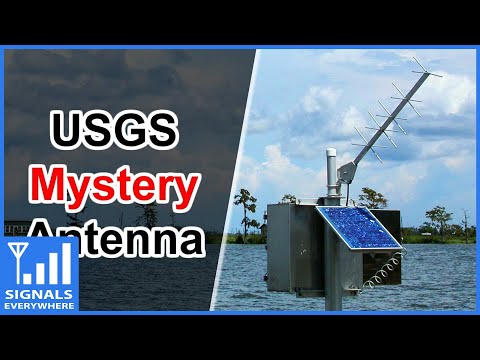
The United States Geological Service maintains over 8500 "Gaging stations" in bodies of water all over the country. Gaging stations are devices that are used to measure environmental data such as groundwater levels, discharge, water chemistry, and water temperature. What's interesting is that they all upload their data in real time to GOES satellites - the same satellites that we can use with an RTL-SDR to receive weather images of the entire earth. The data is then downlinked in the L-band to the USGS scientists via a protocol known as DCP (Data Collection Platform).
In the latest SignalsEverywhere video, Corrosive investigates how these stations work, and how we can receive the downlink at 1.68 GHz with a simple Inmarsat L-band antenna. While a fully functional decoder is not yet available, Corrosive notes that one called goes-dcs is currently being worked on.
USGS Gaging Station | Satellite Uplink to GOES and DCP Messages
In April, a stock research firm told clients that a Gulfstream V owned by Houston-based Occidental Petroleum Corp. had been spotted at an Omaha airport. The immediate speculation was that Occidental executives were negotiating with Buffett’s Berkshire Hathaway Inc. to get financial help in their $38 billion offer for rival Anadarko Petroleum Corp. Two days later, Buffett announced a $10 billion investment in Occidental.
There’s some evidence that aircraft-tracking can be used to get an early read on corporate news. A 2018 paper from security researchers at the University of Oxford and Switzerland’s federal Science and Technology department, tracked aircraft from three dozen public companies and identified seven instances of mergers-and-acquisitions activity. “It probably shouldn’t be your prime source of investing information, but as a feeder, as an alert of something else what might be going on, that’s where this work might be useful,” says Matthew Smith, a researcher at Oxford’s computer science department and one of the authors.
"Alternative data" collection firms like Quandl Inc. have services like "corporate aviation intelligence", where they use ADS-B data to keep tabs on private aircraft, then sell their data on to hedge funds and other investors who are hoping to gain an edge in the stock market.
Popular flight tracking sites that aggregate ADS-B data like FlightAware and FlightRadar24 censor data from private jets on their public maps upon the request of the owner, but it's not known if they continue to sell private jet data on to other parties. ADS-B Exchange is one ADS-B aggregator that promises to never censor flights, however the data is only free for non-commercial use. The value from using companies like Quandl is that they probably have a much more accurate database of who each private jet belongs to.